Lexington night lights from space
Night Light of Lexington (Tennessee) from space (United States) Src. Average luminocity for 10x10km area is 39.8846% and for 50x50km: 4.6125%.
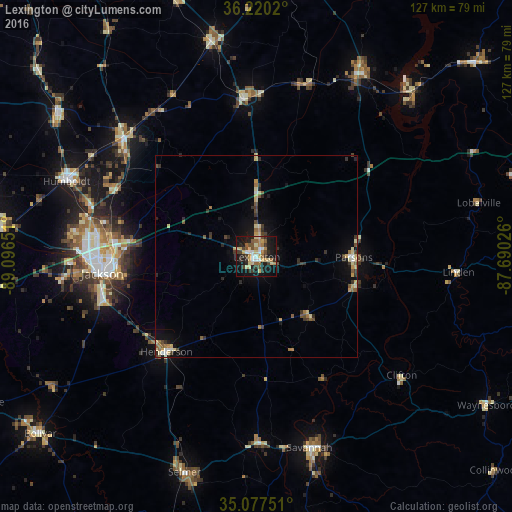
Analysis of Lexington night lights 2016
Square area 10x10 km:
 4.37%
4.37%90-99
3.67%80-89
12.24%70-79
4.37%60-69
4.9%50-59
4.2%40-49
5.59%30-39
7.17%20-29
9.79%10-19
35.66%0-9
8.04%Square area 50x50 km:
0.28%90-99
0.44%80-89
1.15%70-79
0.42%60-69
0.55%50-59
0.65%40-49
0.57%30-39
1.09%20-29
0.97%10-19
2.95%0-9
90.91%Clear (daylight) street map image can be seen on geolist.org.
Map coordinates:
36° 13' 12.7" North, 89° 5' 47.4" West
35° 39' 3.2" North, 88° 23' 36.2" West
35° 4' 39" North, 87° 41' 24.9" West
Some cities around Lexington sort by population:
• Jackson
38.2 km =23.7 mi,  263°
263°
• Humboldt
50.8 km =31.6 mi,  291°
291°
• Milan
44.5 km =27.7 mi,  312°
312°
• Savannah
49.1 km =30.5 mi,  164°
164°
• Henderson
32.5 km =20.2 mi,  223°
223°
• Mount Carmel
38.8 km =24.1 mi,  116°
116°
• McKenzie
54.7 km =34 mi,  348°
348°
• Bolivar
69.5 km =43.2 mi,  230°
230°
4636463 (p: 7,822)
Sources (retrieved 2019-11-25):
» Earth at Night: Flat Maps 2012, 2016