Humboldt night lights from space
Night Light of Humboldt (Tennessee) from space (United States) Src. Average luminocity for 10x10km area is 30.9038% and for 50x50km: 14.9024%.
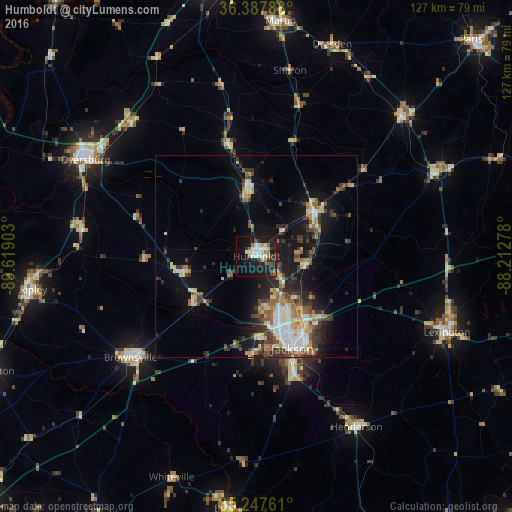
Analysis of Humboldt night lights 2016
Square area 10x10 km:
 6.64%
6.64%90-99
5.24%80-89
2.8%70-79
2.1%60-69
1.75%50-59
5.07%40-49
1.92%30-39
5.42%20-29
6.47%10-19
38.46%0-9
24.13%Square area 50x50 km:
2%90-99
2.4%80-89
1.89%70-79
1.45%60-69
2.11%50-59
1.82%40-49
2.05%30-39
3.39%20-29
3.16%10-19
10.7%0-9
69.03%Clear (daylight) street map image can be seen on geolist.org.
Map coordinates:
36° 23' 16.4" North, 89° 37' 8.5" West
35° 49' 11.2" North, 88° 54' 57.2" West
35° 14' 51.4" North, 88° 12' 46" West
Some cities around Humboldt sort by population:
• Jackson
24.6 km =15.3 mi,  158°
158°
• Dyersburg
48.6 km =30.2 mi,  299°
299°
• Brownsville
40.1 km =24.9 mi,  231°
231°
• Ripley
56 km =34.8 mi,  261°
261°
• Lexington
50.8 km =31.6 mi,  111°
111°
• Milan
18 km =11.2 mi,  51°
51°
• Henderson
49 km =30.4 mi,  149°
149°
• McKenzie
49.9 km =31 mi, 45°
4631291 (p: 8,313)
Sources (retrieved 2019-11-25):
» Earth at Night: Flat Maps 2012, 2016