Lewisburg night lights from space
Night Light of Lewisburg (Tennessee) from space (United States) Src. Average luminocity for 10x10km area is 42.2125% and for 50x50km: 5.2579%.
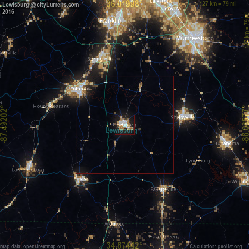
Analysis of Lewisburg night lights 2016
Square area 10x10 km:
 9.16%
9.16%90-99
6.23%80-89
5.31%70-79
5.68%60-69
10.07%50-59
3.85%40-49
1.1%30-39
2.2%20-29
9.16%10-19
41.03%0-9
6.23%Square area 50x50 km:
0.79%90-99
0.57%80-89
0.83%70-79
0.65%60-69
0.75%50-59
0.55%40-49
0.37%30-39
0.81%20-29
1.47%10-19
4.32%0-9
88.9%Clear (daylight) street map image can be seen on geolist.org.
Map coordinates:
36° 1' 11.9" North, 87° 29' 31.3" West
35° 26' 57.3" North, 86° 47' 20" West
34° 52' 27.9" North, 86° 5' 8.8" West
Some cities around Lewisburg sort by population:
• Columbia
28.9 km =18 mi,  309°
309°
• Spring Hill
35.9 km =22.3 mi,  339°
339°
• Shelbyville
30 km =18.6 mi,  82°
82°
• Tullahoma
53.4 km =33.2 mi,  100°
100°
• Christiana
45.6 km =28.3 mi,  50°
50°
• Pulaski
35.4 km =22 mi,  218°
218°
• Fayetteville
38.5 km =23.9 mi,  149°
149°
• Lynchburg
41.9 km =26 mi,  116°
116°
4636442 (p: 11,480)
Sources (retrieved 2019-11-25):
» Earth at Night: Flat Maps 2012, 2016