Pulaski night lights from space
Night Light of Pulaski (Tennessee) from space (United States) Src. Average luminocity for 10x10km area is 31.0839% and for 50x50km: 3.166%.
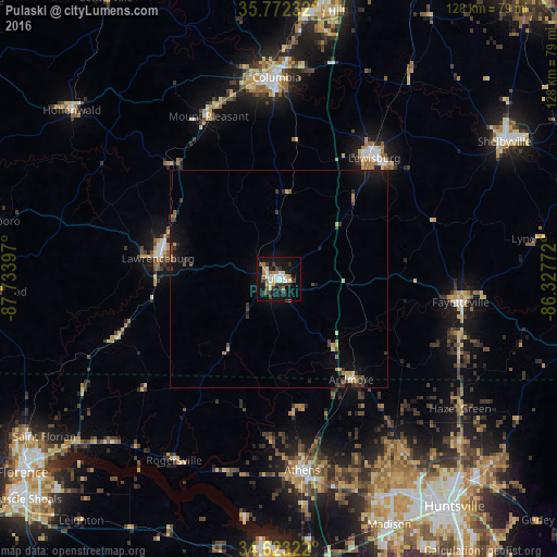
Analysis of Pulaski night lights 2016
Square area 10x10 km:
 5.59%
5.59%90-99
5.24%80-89
4.2%70-79
2.1%60-69
4.72%50-59
2.1%40-49
3.32%30-39
7.52%20-29
3.85%10-19
35.84%0-9
25.52%Square area 50x50 km:
0.26%90-99
0.23%80-89
0.43%70-79
0.37%60-69
0.35%50-59
0.31%40-49
0.41%30-39
1.07%20-29
0.5%10-19
3.11%0-9
92.96%Clear (daylight) street map image can be seen on geolist.org.
Map coordinates:
35° 46' 20.4" North, 87° 44' 2.3" West
35° 11' 59.3" North, 87° 1' 51" West
34° 37' 23.6" North, 86° 19' 39.8" West
Some cities around Pulaski sort by population:
• Columbia
46.2 km =28.7 mi,  359°
359°
• Athens
44.5 km =27.7 mi,  173°
173°
• Lewisburg
35.4 km =22 mi,  38°
38°
• Lawrenceburg
28 km =17.4 mi,  279°
279°
• Fayetteville
42.2 km =26.2 mi,  97°
97°
• Lynchburg
60.3 km =37.5 mi,  81°
81°
• Meridianville
57 km =35.4 mi,  132°
132°
• Harvest
46 km =28.6 mi,  146°
146°
4651648 (p: 7,617)
Sources (retrieved 2019-11-25):
» Earth at Night: Flat Maps 2012, 2016