Lewis Center night lights from space
Night Light of Lewis Center (Ohio) from space (United States) Src. Average luminocity for 10x10km area is 51.1023% and for 50x50km: 35.9429%.
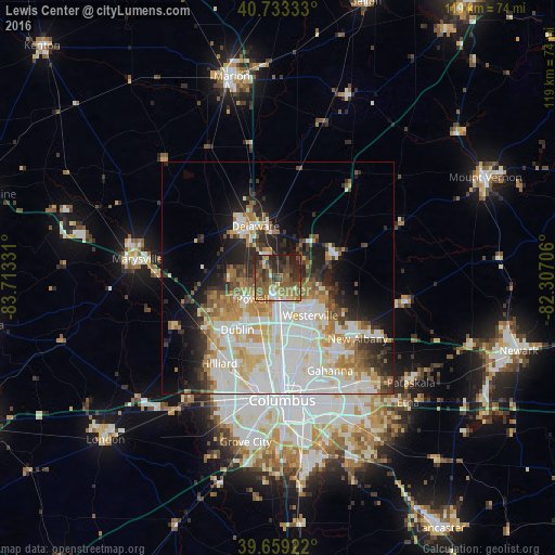
Analysis of Lewis Center night lights 2016
Square area 10x10 km:
 3.73%
3.73%90-99
5.52%80-89
4.38%70-79
5.36%60-69
13.96%50-59
17.21%40-49
15.91%30-39
11.69%20-29
17.69%10-19
4.55%0-9
0%Square area 50x50 km:
10.05%90-99
9.33%80-89
3.94%70-79
4.09%60-69
4.28%50-59
3.33%40-49
2.88%30-39
3.48%20-29
6.19%10-19
8.41%0-9
44.01%Clear (daylight) street map image can be seen on geolist.org.
Map coordinates:
40° 43' 60" North, 83° 42' 47.9" West
40° 11' 54.2" North, 83° 0' 36.6" West
39° 39' 33.2" North, 82° 18' 25.4" West
Some cities around Lewis Center sort by population:
• Dublin
14.1 km =8.8 mi,  218°
218°
• Westerville
10.6 km =6.6 mi,  139°
139°
• Delaware
12.2 km =7.6 mi,  336°
336°
• Hilliard
22.3 km =13.9 mi,  214°
214°
• Worthington
11.7 km =7.3 mi,  183°
183°
• Powell
7.1 km =4.4 mi,  230°
230°
• New Albany
21.5 km =13.4 mi,  127°
127°
• Sunbury
13.7 km =8.5 mi,  69°
69°
5160622 (p: 11,261)
Sources (retrieved 2019-11-25):
» Earth at Night: Flat Maps 2012, 2016