Dublin night lights from space
Night Light of Dublin (Ohio) from space (United States) Src. Average luminocity for 10x10km area is 87.1315% and for 50x50km: 47.68%.
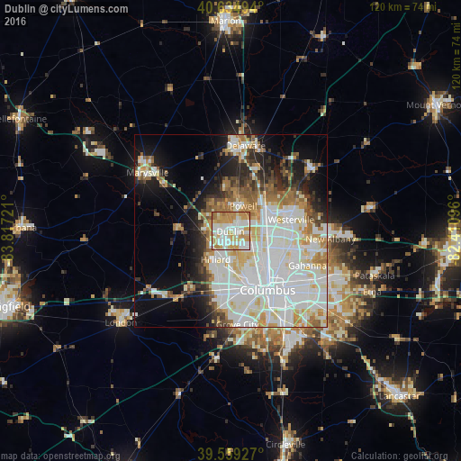

Analysis of Dublin night lights 2016
Square area 10x10 km:
 24.19%
90-99
28.08%80-89
13.31%70-79
21.75%60-69
10.88%50-59
1.79%40-49
0%30-39
0%20-29
0%10-19
0%0-9
0%Square area 50x50 km:
15.84%90-99
13.39%80-89
4.83%70-79
4.92%60-69
4.92%50-59
3.33%40-49
3.01%30-39
3.17%20-29
5.71%10-19
9.79%0-9
31.09%Clear (daylight) street map image can be seen on geolist.org.
Map coordinates:
40° 38' 5.8" North, 83° 49' 2" West
40° 5' 57.2" North, 83° 6' 50.7" West
39° 33' 33.4" North, 82° 24' 39.5" West
Some cities around Dublin sort by population:
• Westerville
16 km =9.9 mi,  79°
79°
• Upper Arlington
12.4 km =7.7 mi,  159°
159°
• Hilliard
8.2 km =5.1 mi,  207°
207°
• Worthington
8.2 km =5.1 mi,  94°
94°
• Powell
7.3 km =4.5 mi,  26°
26°
• Lewis Center
14.1 km =8.8 mi,  38°
38°
• Lincoln Village
16.1 km =10 mi,  185°
185°
• Grandview Heights
14.7 km =9.1 mi,  154°
154°
5152333 (p: 45,098)
Sources (retrieved 2019-11-25):
» Earth at Night: Flat Maps 2012, 2016