Leeds night lights from space
Night Light of Leeds (Alabama) from space (United States) Src. Average luminocity for 10x10km area is 45.511% and for 50x50km: 33.8723%.
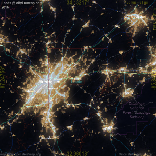
Analysis of Leeds night lights 2016
Square area 10x10 km:
 4.58%
4.58%90-99
4.95%80-89
7.88%70-79
7.51%60-69
9.16%50-59
6.59%40-49
5.49%30-39
8.97%20-29
20.33%10-19
20.88%0-9
3.66%Square area 50x50 km:
5.36%90-99
4.93%80-89
5.05%70-79
6.64%60-69
6.53%50-59
3.55%40-49
3.87%30-39
5.81%20-29
7.61%10-19
11.98%0-9
38.68%Clear (daylight) street map image can be seen on geolist.org.
Map coordinates:
34° 7' 55.8" North, 87° 14' 51.2" West
33° 32' 53.4" North, 86° 32' 39.9" West
32° 57' 36.6" North, 85° 50' 28.7" West
Some cities around Leeds sort by population:
• Trussville
10 km =6.2 mi,  323°
323°
• Center Point
16.8 km =10.4 mi,  310°
310°
• Moody
6.9 km =4.3 mi,  46°
46°
• Irondale
15.1 km =9.4 mi,  265°
265°
• Clay
17.9 km =11.1 mi,  343°
343°
• Lake Purdy
18.2 km =11.3 mi,  223°
223°
• Brook Highland
17.3 km =10.7 mi, 223°
• Grayson Valley
14.2 km =8.8 mi, 321°
4072130 (p: 11,936)
Sources (retrieved 2019-11-25):
» Earth at Night: Flat Maps 2012, 2016