Lake Purdy night lights from space
Night Light of Lake Purdy (Alabama) from space (United States) Src. Average luminocity for 10x10km area is 66.5629% and for 50x50km: 45.486%.
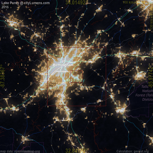
Analysis of Lake Purdy night lights 2016
Square area 10x10 km:
 9.62%
9.62%90-99
11.01%80-89
8.22%70-79
9.27%60-69
24.83%50-59
15.91%40-49
9.44%30-39
6.64%20-29
5.07%10-19
0%0-9
0%Square area 50x50 km:
9.78%90-99
7.8%80-89
6.92%70-79
9.22%60-69
8.72%50-59
4.69%40-49
4.67%30-39
5.26%20-29
6.67%10-19
7.52%0-9
28.76%Clear (daylight) street map image can be seen on geolist.org.
Map coordinates:
34° 0' 53.7" North, 87° 23' 1.2" West
33° 25' 48.4" North, 86° 40' 49.9" West
32° 50' 28.8" North, 85° 58' 38.7" West
Some cities around Lake Purdy sort by population:
• Vestavia Hills
10.2 km =6.3 mi,  281°
281°
• Homewood
12.1 km =7.5 mi,  292°
292°
• Mountain Brook
10.3 km =6.4 mi,  319°
319°
• Irondale
12.3 km =7.6 mi,  348°
348°
• Chelsea
11 km =6.8 mi,  154°
154°
• Meadowbrook
3.5 km =2.2 mi,  205°
205°
• Brook Highland
0.9 km =0.6 mi,  45°
45°
• Cahaba Heights
6.1 km =3.8 mi,  308°
308°
4071488 (p: 7,857)
Sources (retrieved 2019-11-25):
» Earth at Night: Flat Maps 2012, 2016