Center Point night lights from space
Night Light of Center Point (Alabama) from space (United States) Src. Average luminocity for 10x10km area is 75.9615% and for 50x50km: 38.669%.
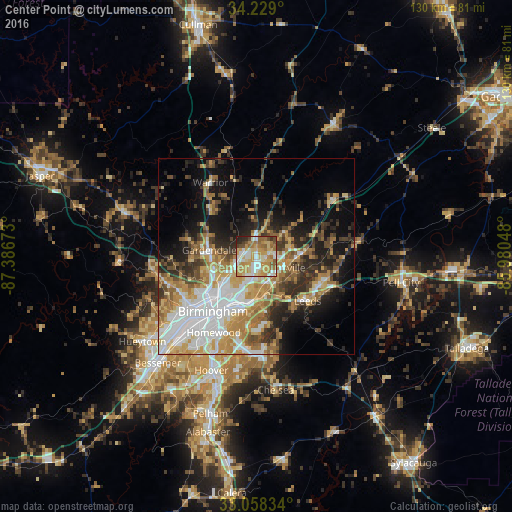
Analysis of Center Point night lights 2016
Square area 10x10 km:
 11.17%
90-99
17.22%80-89
17.58%70-79
23.99%60-69
12.45%50-59
6.41%40-49
4.58%30-39
2.38%20-29
4.21%10-19
0%0-9
0%Square area 50x50 km:
8.54%90-99
6.31%80-89
5.54%70-79
6.76%60-69
6.23%50-59
3.95%40-49
4.34%30-39
5.34%20-29
7.04%10-19
11.98%0-9
33.97%Clear (daylight) street map image can be seen on geolist.org.
Map coordinates:
34° 13' 44.4" North, 87° 23' 12.2" West
33° 38' 44.4" North, 86° 41' 1" West
33° 3' 30" North, 85° 58' 49.7" West
Some cities around Center Point sort by population:
• Dixiana
11 km =6.8 mi,  16°
16°
• Trussville
7.5 km =4.7 mi,  112°
112°
• Gardendale
12.1 km =7.5 mi,  277°
277°
• Clay
10 km =6.2 mi,  50°
50°
• Fultondale
11.2 km =7 mi,  246°
246°
• Pinson
4.8 km =3 mi,  0°
0°
• Tarrant
10.8 km =6.7 mi,  230°
230°
• Grayson Valley
4.1 km =2.5 mi,  86°
86°
4054378 (p: 16,655)
Sources (retrieved 2019-11-25):
» Earth at Night: Flat Maps 2012, 2016