Clay night lights from space
Night Light of Clay (Alabama) from space (United States) Src. Average luminocity for 10x10km area is 36.793% and for 50x50km: 28.9143%.
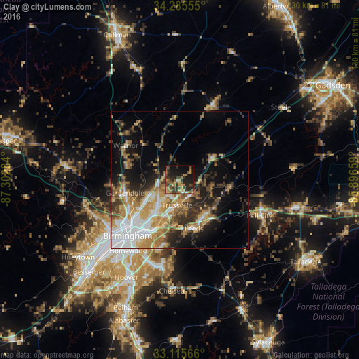
Analysis of Clay night lights 2016
Square area 10x10 km:
 0.73%
0.73%90-99
1.1%80-89
5.31%70-79
7.33%60-69
5.68%50-59
9.16%40-49
8.42%30-39
13.37%20-29
16.67%10-19
23.44%0-9
8.79%Square area 50x50 km:
5.76%90-99
3.58%80-89
3.98%70-79
5%60-69
5.01%50-59
3.23%40-49
3.69%30-39
5.02%20-29
6.1%10-19
11.14%0-9
47.49%Clear (daylight) street map image can be seen on geolist.org.
Map coordinates:
34° 17' 8" North, 87° 18' 10.2" West
33° 42' 9.4" North, 86° 35' 59" West
33° 6' 56.4" North, 85° 53' 47.7" West
Some cities around Clay sort by population:
• Dixiana
6.2 km =3.9 mi,  312°
312°
• Trussville
9.2 km =5.7 mi,  185°
185°
• Center Point
10 km =6.2 mi,  230°
230°
• Gardendale
20.3 km =12.6 mi,  256°
256°
• Moody
16 km =9.9 mi,  140°
140°
• Leeds
17.9 km =11.1 mi,  163°
163°
• Pinson
7.9 km =4.9 mi, 258°
• Grayson Valley
7.1 km =4.4 mi,  211°
211°
4055650 (p: 9,655)
Sources (retrieved 2019-11-25):
» Earth at Night: Flat Maps 2012, 2016