Brook Highland night lights from space
Night Light of Brook Highland (Alabama) from space (United States) Src. Average luminocity for 10x10km area is 63.785% and for 50x50km: 45.0905%.
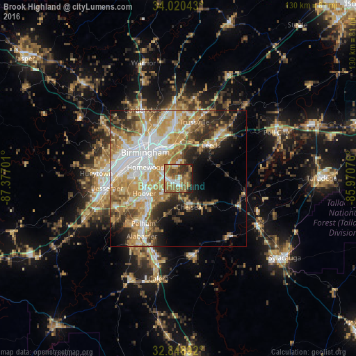
Analysis of Brook Highland night lights 2016
Square area 10x10 km:
 8.39%
8.39%90-99
9.62%80-89
7.34%70-79
8.74%60-69
25%50-59
16.08%40-49
9.09%30-39
6.82%20-29
8.04%10-19
0.87%0-9
0%Square area 50x50 km:
9.72%90-99
7.69%80-89
6.8%70-79
9.2%60-69
8.7%50-59
4.57%40-49
4.69%30-39
5.19%20-29
6.48%10-19
7.59%0-9
29.38%Clear (daylight) street map image can be seen on geolist.org.
Map coordinates:
34° 1' 13.5" North, 87° 22' 37.2" West
33° 26' 8.4" North, 86° 40' 26" West
32° 50' 48.9" North, 85° 58' 14.7" West
Some cities around Brook Highland sort by population:
• Vestavia Hills
10.7 km =6.6 mi,  277°
277°
• Homewood
12.4 km =7.7 mi,  288°
288°
• Mountain Brook
10.3 km =6.4 mi,  314°
314°
• Irondale
11.8 km =7.3 mi,  344°
344°
• Chelsea
11.4 km =7.1 mi,  159°
159°
• Meadowbrook
4.3 km =2.7 mi,  209°
209°
• Lake Purdy
0.9 km =0.6 mi,  225°
225°
• Cahaba Heights
6.2 km =3.9 mi,  300°
300°
4051894 (p: 6,746)
Sources (retrieved 2019-11-25):
» Earth at Night: Flat Maps 2012, 2016