Anderson Mill night lights from space
Night Light of Anderson Mill (Texas) from space (United States) Src. Average luminocity for 10x10km area is 73.9744% and for 50x50km: 45.997%.
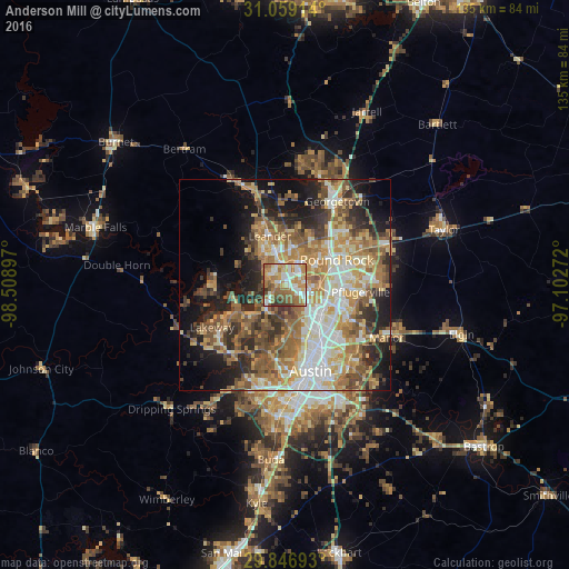
Analysis of Anderson Mill night lights 2016
Square area 10x10 km:
 13.92%
90-99
17.77%80-89
6.78%70-79
14.65%60-69
21.98%50-59
14.1%40-49
5.86%30-39
3.85%20-29
1.1%10-19
0%0-9
0%Square area 50x50 km:
7.26%90-99
7.71%80-89
6.83%70-79
7.79%60-69
9.06%50-59
8.75%40-49
6.65%30-39
5.49%20-29
8.56%10-19
11.63%0-9
20.27%Clear (daylight) street map image can be seen on geolist.org.
Map coordinates:
31° 3' 32.9" North, 98° 30' 32.3" West
30° 27' 17.7" North, 97° 48' 21" West
29° 50' 48.9" North, 97° 6' 9.8" West
Some cities around Anderson Mill sort by population:
• Round Rock
13.5 km =8.4 mi,  64°
64°
• Cedar Park
5.8 km =3.6 mi,  346°
346°
• Pflugerville
17.9 km =11.1 mi,  95°
95°
• Leander
14.5 km =9 mi,  341°
341°
• Brushy Creek
9.1 km =5.7 mi,  44°
44°
• Jollyville
3.3 km =2.1 mi,  114°
114°
• Wells Branch
12.2 km =7.6 mi,  94°
94°
• Lago Vista
17.5 km =10.9 mi,  271°
271°
4670783 (p: 8,744)
Sources (retrieved 2019-11-25):
» Earth at Night: Flat Maps 2012, 2016