Lake Mohegan night lights from space
Night Light of Lake Mohegan (New York) from space (United States) Src. Average luminocity for 10x10km area is 38.5663% and for 50x50km: 26.0783%.
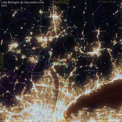
Analysis of Lake Mohegan night lights 2016
Square area 10x10 km:
 0.34%
0.34%90-99
1.7%80-89
3.74%70-79
10.71%60-69
7.31%50-59
9.01%40-49
7.65%30-39
13.95%20-29
14.8%10-19
27.21%0-9
3.57%Square area 50x50 km:
1.87%90-99
2.8%80-89
3.75%70-79
3.43%60-69
4.26%50-59
4.7%40-49
4.94%30-39
5.26%20-29
9.75%10-19
20.41%0-9
38.83%Clear (daylight) street map image can be seen on geolist.org.
Map coordinates:
41° 50' 37.8" North, 74° 32' 57.8" West
41° 19' 4.3" North, 73° 50' 46.5" West
40° 47' 15.5" North, 73° 8' 35.3" West
Some cities around Lake Mohegan sort by population:
• Peekskill
6.9 km =4.3 mi,  243°
243°
• Jefferson Valley-Yorktown
3.8 km =2.4 mi,  89°
89°
• Haverstraw
16.6 km =10.3 mi,  216°
216°
• Stony Point
15.3 km =9.5 mi,  230°
230°
• Mount Kisco
16.1 km =10 mi,  141°
141°
• Mahopac
11.2 km =7 mi,  57°
57°
• Croton-on-Hudson
12.7 km =7.9 mi,  197°
197°
• West Point
12.3 km =7.6 mi,  311°
311°
5123823 (p: 6,010)
Sources (retrieved 2019-11-25):
» Earth at Night: Flat Maps 2012, 2016