Lackawanna night lights from space
Night Light of Lackawanna (New York) from space (United States) Src. Average luminocity for 10x10km area is 74.8924% and for 50x50km: 30.008%.
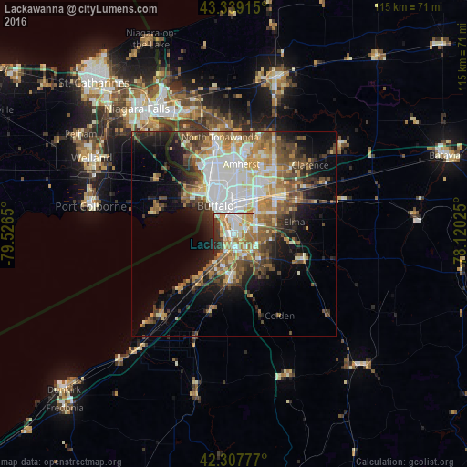
Analysis of Lackawanna night lights 2016
Square area 10x10 km:
 16.97%
90-99
21.36%80-89
9.24%70-79
14.85%60-69
18.33%50-59
3.03%40-49
0.76%30-39
7.73%20-29
7.73%10-19
0%0-9
0%Square area 50x50 km:
6.64%90-99
5.81%80-89
3.17%70-79
3.81%60-69
4.32%50-59
4.69%40-49
4.65%30-39
3.67%20-29
5.12%10-19
8.65%0-9
49.47%Clear (daylight) street map image can be seen on geolist.org.
Map coordinates:
43° 20' 20.9" North, 79° 31' 35.4" West
42° 49' 32.2" North, 78° 49' 24.1" West
42° 18' 28" North, 78° 7' 12.9" West
Some cities around Lackawanna sort by population:
• Buffalo
8.1 km =5 mi,  326°
326°
• Cheektowaga
10.3 km =6.4 mi,  32°
32°
• West Seneca
3.3 km =2.1 mi,  35°
35°
• Fort Erie, CA
12.2 km =7.6 mi,  312°
312°
• Depew
13.8 km =8.6 mi,  50°
50°
• Eggertsville
15.4 km =9.6 mi,  5°
5°
• Lancaster
15 km =9.3 mi,  56°
56°
• Hamburg
12.2 km =7.6 mi,  182°
182°
5123718 (p: 17,965)
Sources (retrieved 2019-11-25):
» Earth at Night: Flat Maps 2012, 2016