La Crescenta-Montrose night lights from space
Night Light of La Crescenta-Montrose (California) from space (United States) Src. Average luminocity for 10x10km area is 51.5073% and for 50x50km: 53.1579%.
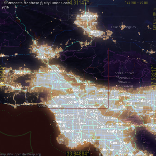
Analysis of La Crescenta-Montrose night lights 2016
Square area 10x10 km:
 3.66%
3.66%90-99
6.78%80-89
2.75%70-79
5.68%60-69
23.63%50-59
17.95%40-49
6.78%30-39
8.06%20-29
6.96%10-19
13.37%0-9
4.4%Square area 50x50 km:
22.7%90-99
13.73%80-89
5.23%70-79
5.38%60-69
5.76%50-59
3.31%40-49
2.26%30-39
1.98%20-29
2.33%10-19
4.21%0-9
33.11%Clear (daylight) street map image can be seen on geolist.org.
Map coordinates:
34° 48' 41.3" North, 118° 56' 18.3" West
34° 13' 55.8" North, 118° 14' 7" West
33° 38' 55.8" North, 117° 31' 55.8" West
Some cities around La Crescenta-Montrose sort by population:
• Glendale
10.1 km =6.3 mi,  190°
190°
• Pasadena
12.6 km =7.8 mi,  138°
138°
• Burbank
8.9 km =5.5 mi,  229°
229°
• Altadena
10.7 km =6.6 mi,  116°
116°
• Tujunga
5.4 km =3.4 mi,  294°
294°
• La Cañada Flintridge
5.7 km =3.5 mi,  130°
130°
• Sunland
7.3 km =4.5 mi,  302°
302°
• Shadow Hills
11.2 km =7 mi, 287°
7261553 (p: 19,653)
Sources (retrieved 2019-11-25):
» Earth at Night: Flat Maps 2012, 2016