Shadow Hills night lights from space
Night Light of Shadow Hills (California) from space (United States) Src. Average luminocity for 10x10km area is 64.6575% and for 50x50km: 55.3785%.
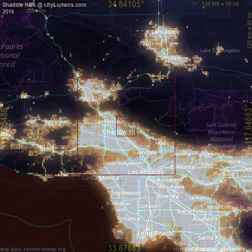
Analysis of Shadow Hills night lights 2016
Square area 10x10 km:
 12.27%
90-99
10.07%80-89
1.65%70-79
8.42%60-69
26.92%50-59
19.6%40-49
7.33%30-39
3.48%20-29
5.31%10-19
4.95%0-9
0%Square area 50x50 km:
19.37%90-99
13.54%80-89
5.86%70-79
6.42%60-69
8.55%50-59
4.8%40-49
3.62%30-39
3.54%20-29
4.25%10-19
5.36%0-9
24.7%Clear (daylight) street map image can be seen on geolist.org.
Map coordinates:
34° 50' 27.8" North, 119° 3' 17.6" West
34° 15' 43" North, 118° 21' 6.3" West
33° 40' 43.8" North, 117° 38' 55.1" West
Some cities around Shadow Hills sort by population:
• Van Nuys
12.2 km =7.6 mi,  226°
226°
• Burbank
9.8 km =6.1 mi,  156°
156°
• North Hollywood
10.3 km =6.4 mi,  194°
194°
• Valley Glen
12 km =7.5 mi, 228°
• Tujunga
5.9 km =3.7 mi,  100°
100°
• San Fernando
8.3 km =5.2 mi,  285°
285°
• La Crescenta-Montrose
11.2 km =7 mi,  107°
107°
• Sunland
4.6 km =2.9 mi,  83°
83°
5394814 (p: 13,000)
Sources (retrieved 2019-11-25):
» Earth at Night: Flat Maps 2012, 2016