Kerman night lights from space
Night Light of Kerman (California) from space (United States) Src. Average luminocity for 10x10km area is 13.1813% and for 50x50km: 10.3173%.
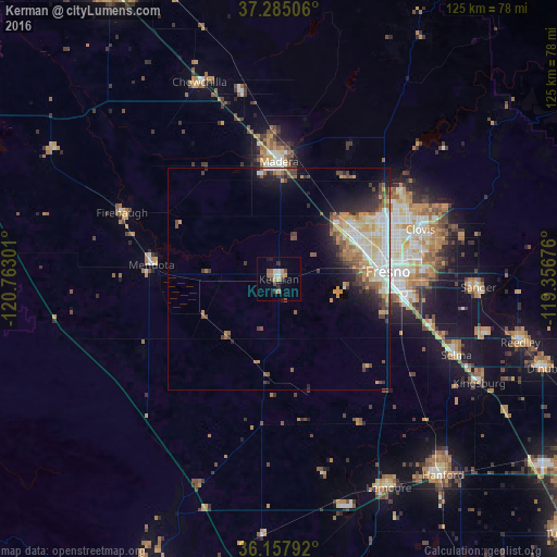
Analysis of Kerman night lights 2016
Square area 10x10 km:
 1.1%
1.1%90-99
1.1%80-89
1.47%70-79
2.2%60-69
3.11%50-59
1.28%40-49
2.2%30-39
2.56%20-29
1.65%10-19
1.65%0-9
81.68%Square area 50x50 km:
1.63%90-99
1.94%80-89
1.27%70-79
1.92%60-69
1.14%50-59
1.28%40-49
1.56%30-39
1.53%20-29
1.81%10-19
4.21%0-9
81.69%Clear (daylight) street map image can be seen on geolist.org.
Map coordinates:
37° 17' 6.2" North, 120° 45' 46.8" West
36° 43' 24.8" North, 120° 3' 35.6" West
36° 9' 28.5" North, 119° 21' 24.3" West
Some cities around Kerman sort by population:
• Fresno
25.8 km =16 mi,  84°
84°
• Clovis
33.7 km =20.9 mi,  70°
70°
• Madera
26.4 km =16.4 mi,  359°
359°
• Mendota
28.9 km =18 mi,  276°
276°
• Madera Acres
32.9 km =20.4 mi, 358°
• Bonadelle Ranchos-Madera Ranchos
33.4 km =20.8 mi,  29°
29°
• Fowler
35.6 km =22.1 mi,  106°
106°
• Old Fig Garden
24.2 km =15 mi, 69°
5362909 (p: 14,475)
Sources (retrieved 2019-11-25):
» Earth at Night: Flat Maps 2012, 2016