Old Fig Garden night lights from space
Night Light of Old Fig Garden (California) from space (United States) Src. Average luminocity for 10x10km area is 92.479% and for 50x50km: 24.0153%.
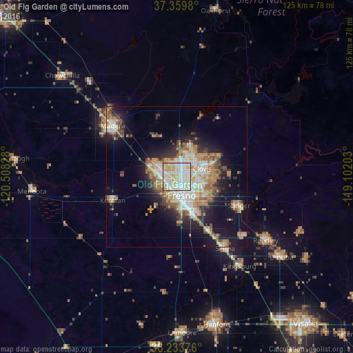
Analysis of Old Fig Garden night lights 2016
Square area 10x10 km:
 30.24%
90-99
38.29%80-89
21.68%70-79
7.17%60-69
2.1%50-59
0.52%40-49
0%30-39
0%20-29
0%10-19
0%0-9
0%Square area 50x50 km:
4.23%90-99
4.97%80-89
2.52%70-79
4.57%60-69
3.5%50-59
2.38%40-49
2.81%30-39
3.16%20-29
3.72%10-19
11.35%0-9
56.77%Clear (daylight) street map image can be seen on geolist.org.
Map coordinates:
37° 21' 35.3" North, 120° 30' 29.8" West
36° 47' 55.9" North, 119° 48' 18.5" West
36° 14' 1.5" North, 119° 6' 7.3" West
Some cities around Old Fig Garden sort by population:
• Fresno
6.4 km =4 mi,  152°
152°
• Clovis
9.6 km =6 mi,  72°
72°
• Madera
29 km =18 mi,  308°
308°
• Sanger
24.4 km =15.2 mi,  114°
114°
• Selma
30.7 km =19.1 mi, 145°
• Kerman
24.2 km =15 mi,  249°
249°
• Bonadelle Ranchos-Madera Ranchos
21.6 km =13.4 mi,  343°
343°
• Fowler
21.9 km =13.6 mi, 148°
7315205 (p: 5,365)
Sources (retrieved 2019-11-25):
» Earth at Night: Flat Maps 2012, 2016