Madera Acres night lights from space
Night Light of Madera Acres (California) from space (United States) Src. Average luminocity for 10x10km area is 23.3946% and for 50x50km: 8.1482%.
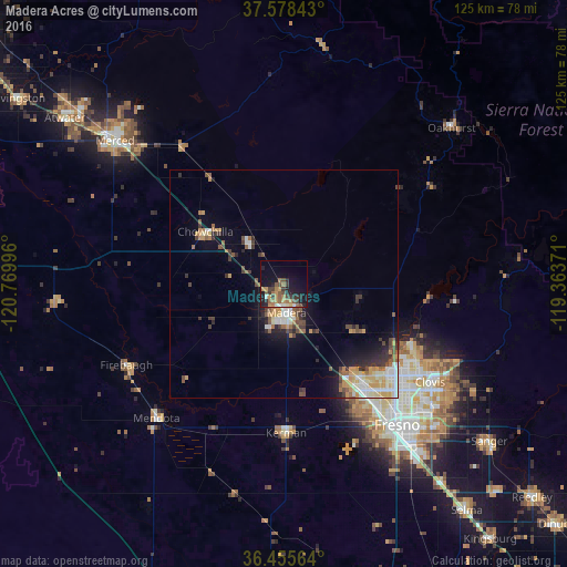
Analysis of Madera Acres night lights 2016
Square area 10x10 km:
 0.51%
0.51%90-99
1.53%80-89
0.34%70-79
5.61%60-69
6.63%50-59
4.59%40-49
4.76%30-39
5.61%20-29
5.61%10-19
22.79%0-9
42.01%Square area 50x50 km:
1.01%90-99
1.26%80-89
0.78%70-79
1.66%60-69
0.95%50-59
1.17%40-49
1.22%30-39
1.55%20-29
1.45%10-19
4.24%0-9
84.73%Clear (daylight) street map image can be seen on geolist.org.
Map coordinates:
37° 34' 42.3" North, 120° 46' 11.9" West
37° 1' 8.8" North, 120° 4' 0.6" West
36° 27' 20.3" North, 119° 21' 49.4" West
Some cities around Madera Acres sort by population:
• Fresno
40 km =24.9 mi,  139°
139°
• Clovis
38.9 km =24.2 mi,  123°
123°
• Chowchilla
20.7 km =12.9 mi,  303°
303°
• Kerman
32.9 km =20.4 mi,  178°
178°
• Mendota
40.7 km =25.3 mi,  223°
223°
• Bonadelle Ranchos-Madera Ranchos
17.5 km =10.9 mi,  102°
102°
• Firebaugh
38.9 km =24.2 mi,  242°
242°
• Old Fig Garden
33.8 km =21 mi, 136°
5369569 (p: 9,163)
Sources (retrieved 2019-11-25):
» Earth at Night: Flat Maps 2012, 2016