Bonadelle Ranchos-Madera Ranchos night lights from space
Night Light of Bonadelle Ranchos-Madera Ranchos (California) from space (United States) Src. Average luminocity for 10x10km area is 1.0049% and for 50x50km: 15.5711%.
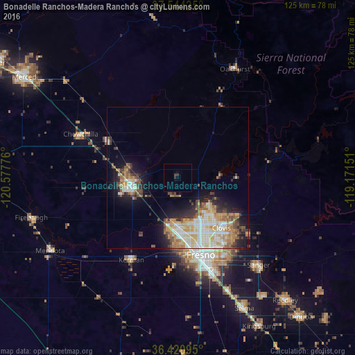
Analysis of Bonadelle Ranchos-Madera Ranchos night lights 2016
Square area 10x10 km:
 0%
0%90-99
0%80-89
0%70-79
0%60-69
0%50-59
0%40-49
0%30-39
1.14%20-29
0.81%10-19
0%0-9
98.05%Square area 50x50 km:
2.71%90-99
3.41%80-89
1.94%70-79
2.8%60-69
2.21%50-59
1.6%40-49
1.7%30-39
1.99%20-29
2.41%10-19
6.26%0-9
72.98%Clear (daylight) street map image can be seen on geolist.org.
Map coordinates:
37° 32' 39.3" North, 120° 34' 39.9" West
36° 59' 4.8" North, 119° 52' 28.7" West
36° 25' 15.4" North, 119° 10' 17.4" West
Some cities around Bonadelle Ranchos-Madera Ranchos sort by population:
• Fresno
27.9 km =17.3 mi,  160°
160°
• Clovis
23.4 km =14.5 mi,  139°
139°
• Madera
16.7 km =10.4 mi,  261°
261°
• Sanger
41.8 km =26 mi, 137°
• Chowchilla
37.5 km =23.3 mi,  294°
294°
• Kerman
33.4 km =20.8 mi,  209°
209°
• Madera Acres
17.5 km =10.9 mi,  282°
282°
• Old Fig Garden
21.6 km =13.4 mi, 163°
7260929 (p: 8,569)
Sources (retrieved 2019-11-25):
» Earth at Night: Flat Maps 2012, 2016