Joppatowne night lights from space
Night Light of Joppatowne (Maryland) from space (United States) Src. Average luminocity for 10x10km area is 60.0323% and for 50x50km: 33.8868%.
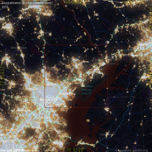
Analysis of Joppatowne night lights 2016
Square area 10x10 km:
 7.65%
7.65%90-99
8.33%80-89
8.5%70-79
8.16%60-69
10.2%50-59
14.46%40-49
21.94%30-39
16.5%20-29
4.25%10-19
0%0-9
0%Square area 50x50 km:
9.88%90-99
5.73%80-89
3.56%70-79
3.98%60-69
4%50-59
4%40-49
4.44%30-39
5.33%20-29
7.37%10-19
9.72%0-9
42%Clear (daylight) street map image can be seen on geolist.org.
Map coordinates:
39° 59' 55.1" North, 77° 3' 30.1" West
39° 27' 28.4" North, 76° 21' 18.9" West
38° 54' 46.4" North, 75° 39' 7.6" West
Some cities around Joppatowne sort by population:
• South Bel Air
8.5 km =5.3 mi,  10°
10°
• Bel Air South
6.1 km =3.8 mi,  30°
30°
• North Bel Air
9.1 km =5.7 mi,  0°
0°
• Edgewood
6.8 km =4.2 mi,  129°
129°
• Bel Air
8.7 km =5.4 mi, 3°
• White Marsh
10.6 km =6.6 mi,  218°
218°
• Fallston
7.9 km =4.9 mi,  322°
322°
• Riverside
9.9 km =6.2 mi,  79°
79°
4359619 (p: 12,616)
Sources (retrieved 2019-11-25):
» Earth at Night: Flat Maps 2012, 2016