White Marsh night lights from space
Night Light of White Marsh (Maryland) from space (United States) Src. Average luminocity for 10x10km area is 73.398% and for 50x50km: 44.8983%.
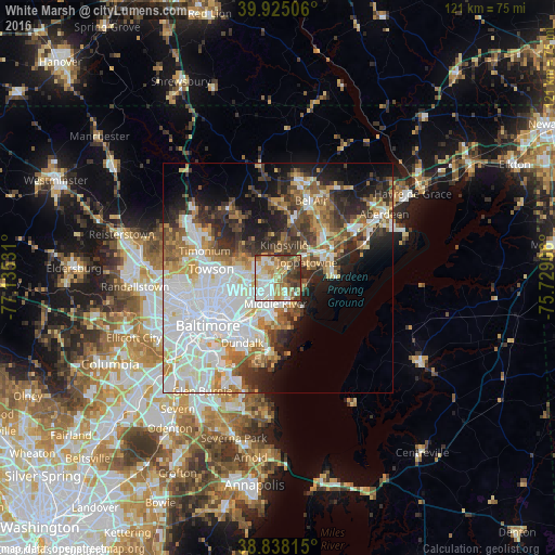
Analysis of White Marsh night lights 2016
Square area 10x10 km:
 15.82%
90-99
17.18%80-89
13.61%70-79
12.93%60-69
11.05%50-59
8.67%40-49
10.71%30-39
9.01%20-29
1.02%10-19
0%0-9
0%Square area 50x50 km:
14.62%90-99
9.39%80-89
4.54%70-79
5.15%60-69
4.69%50-59
4.91%40-49
5.23%30-39
5.43%20-29
7.32%10-19
9.27%0-9
29.46%Clear (daylight) street map image can be seen on geolist.org.
Map coordinates:
39° 55' 30.2" North, 77° 8' 7.1" West
39° 23' 1.4" North, 76° 25' 55.8" West
38° 50' 17.3" North, 75° 43' 44.6" West
Some cities around White Marsh sort by population:
• Essex
9.1 km =5.7 mi,  203°
203°
• Parkville
9.3 km =5.8 mi,  265°
265°
• Carney
7.9 km =4.9 mi,  278°
278°
• Perry Hall
4.2 km =2.6 mi,  319°
319°
• Middle River
5.5 km =3.4 mi,  186°
186°
• Rossville
6.5 km =4 mi,  219°
219°
• Overlea
7.9 km =4.9 mi,  253°
253°
• Bowleys Quarters
6.5 km =4 mi,  146°
146°
4373426 (p: 9,513)
Sources (retrieved 2019-11-25):
» Earth at Night: Flat Maps 2012, 2016