Bel Air night lights from space
Night Light of Bel Air (Maryland) from space (United States) Src. Average luminocity for 10x10km area is 62.9058% and for 50x50km: 27.9201%.
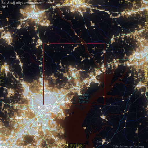
Analysis of Bel Air night lights 2016
Square area 10x10 km:
 7.47%
7.47%90-99
9.42%80-89
9.25%70-79
10.06%60-69
13.64%50-59
22.24%40-49
13.96%30-39
7.14%20-29
6.01%10-19
0.81%0-9
0%Square area 50x50 km:
6.46%90-99
4.31%80-89
3.1%70-79
3.45%60-69
3.56%50-59
3.75%40-49
4.5%30-39
5.23%20-29
7.2%10-19
9.56%0-9
48.88%Clear (daylight) street map image can be seen on geolist.org.
Map coordinates:
40° 4' 33.9" North, 77° 3' 5.1" West
39° 32' 9.4" North, 76° 20' 53.8" West
38° 59' 29.6" North, 75° 38' 42.6" West
Some cities around Bel Air sort by population:
• South Bel Air
1 km =0.6 mi,  108°
108°
• North Bel Air
0.7 km =0.4 mi,  307°
307°
• Perry Hall
16.9 km =10.5 mi,  215°
215°
• Edgewood
13.8 km =8.6 mi,  160°
160°
• Aberdeen
16.1 km =10 mi,  100°
100°
• Joppatowne
8.7 km =5.4 mi,  183°
183°
• Fallston
5.9 km =3.7 mi,  246°
246°
• Riverside
11.5 km =7.1 mi,  127°
127°
4348240 (p: 10,190)
Sources (retrieved 2019-11-25):
» Earth at Night: Flat Maps 2012, 2016