Wells Branch night lights from space
Night Light of Wells Branch (Texas) from space (United States) Src. Average luminocity for 10x10km area is 86.7106% and for 50x50km: 45.4321%.
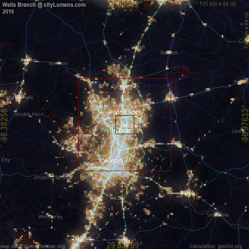
Analysis of Wells Branch night lights 2016
Square area 10x10 km:
 23.08%
90-99
28.39%80-89
15.02%70-79
19.78%60-69
10.81%50-59
2.56%40-49
0.37%30-39
0%20-29
0%10-19
0%0-9
0%Square area 50x50 km:
7.49%90-99
7.94%80-89
6.48%70-79
7.86%60-69
9.06%50-59
8.42%40-49
5.99%30-39
5.16%20-29
7.99%10-19
10.07%0-9
23.54%Clear (daylight) street map image can be seen on geolist.org.
Map coordinates:
31° 3' 1.2" North, 98° 22' 57.3" West
30° 26' 45.7" North, 97° 40' 46" West
29° 50' 16.8" North, 96° 58' 34.8" West
Some cities around Wells Branch sort by population:
• Round Rock
6.9 km =4.3 mi,  0°
0°
• Cedar Park
15 km =9.3 mi,  295°
295°
• Pflugerville
5.7 km =3.5 mi,  97°
97°
• Hutto
16.7 km =10.4 mi,  49°
49°
• Brushy Creek
9.5 km =5.9 mi,  322°
322°
• Jollyville
9.2 km =5.7 mi,  267°
267°
• Anderson Mill
12.2 km =7.6 mi, 274°
• Manor
16.6 km =10.3 mi,  134°
134°
4740584 (p: 12,120)
Sources (retrieved 2019-11-25):
» Earth at Night: Flat Maps 2012, 2016