Jasper night lights from space
Night Light of Jasper (Alabama) from space (United States) Src. Average luminocity for 10x10km area is 50.1748% and for 50x50km: 8.0717%.
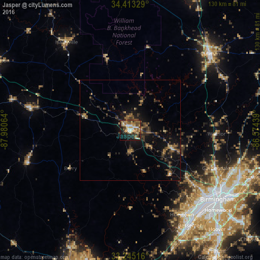
Analysis of Jasper night lights 2016
Square area 10x10 km:
 8.22%
8.22%90-99
5.59%80-89
7.87%70-79
9.09%60-69
8.92%50-59
9.27%40-49
9.97%30-39
7.34%20-29
9.79%10-19
19.23%0-9
4.72%Square area 50x50 km:
0.38%90-99
0.29%80-89
0.92%70-79
0.94%60-69
1.19%50-59
1.45%40-49
2.23%30-39
2.3%20-29
2.78%10-19
6.28%0-9
81.23%Clear (daylight) street map image can be seen on geolist.org.
Map coordinates:
34° 24' 47.8" North, 87° 58' 50.3" West
33° 49' 52.4" North, 87° 16' 39" West
33° 14' 42.6" North, 86° 34' 27.8" West
Some cities around Jasper sort by population:
• Hueytown
49.6 km =30.8 mi,  148°
148°
• Gardendale
47 km =29.2 mi,  113°
113°
• Fairfield
51.2 km =31.8 mi,  138°
138°
• Pleasant Grove
47.3 km =29.4 mi, 143°
• Forestdale
45.7 km =28.4 mi,  129°
129°
• Fultondale
51.3 km =31.9 mi,  119°
119°
• Tarrant
54.2 km =33.7 mi, 120°
• Midfield
53.4 km =33.2 mi, 140°
4069659 (p: 14,071)
Sources (retrieved 2019-11-25):
» Earth at Night: Flat Maps 2012, 2016