Hartford night lights from space
Night Light of Hartford (Wisconsin) from space (United States) Src. Average luminocity for 10x10km area is 25.2045% and for 50x50km: 15.3047%.
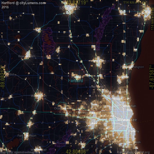
Analysis of Hartford night lights 2016
Square area 10x10 km:
 1.97%
1.97%90-99
2.73%80-89
5.3%70-79
3.64%60-69
5.15%50-59
1.52%40-49
2.27%30-39
2.88%20-29
2.27%10-19
33.64%0-9
38.64%Square area 50x50 km:
1.3%90-99
1.63%80-89
2.48%70-79
2.11%60-69
2.34%50-59
2.46%40-49
2.78%30-39
2.15%20-29
4.55%10-19
11.45%0-9
66.74%Clear (daylight) street map image can be seen on geolist.org.
Map coordinates:
43° 49' 37.9" North, 89° 4' 55.6" West
43° 19' 4" North, 88° 22' 44.4" West
42° 48' 14.6" North, 87° 40' 33.1" West
Some cities around Hartford sort by population:
• West Bend
19.8 km =12.3 mi,  52°
52°
• Germantown
23.9 km =14.9 mi,  114°
114°
• Oconomowoc
24.9 km =15.5 mi,  203°
203°
• Richfield
16.5 km =10.3 mi, 114°
• Sussex
24.1 km =15 mi,  148°
148°
• Hartland
23.8 km =14.8 mi,  172°
172°
• Jackson
17.2 km =10.7 mi,  87°
87°
• Slinger
7.7 km =4.8 mi,  76°
76°
5255628 (p: 14,355)
Sources (retrieved 2019-11-25):
» Earth at Night: Flat Maps 2012, 2016