Inverness night lights from space
Night Light of Inverness (Illinois) from space (United States) Src. Average luminocity for 10x10km area is 72.8712% and for 50x50km: 73.1997%.
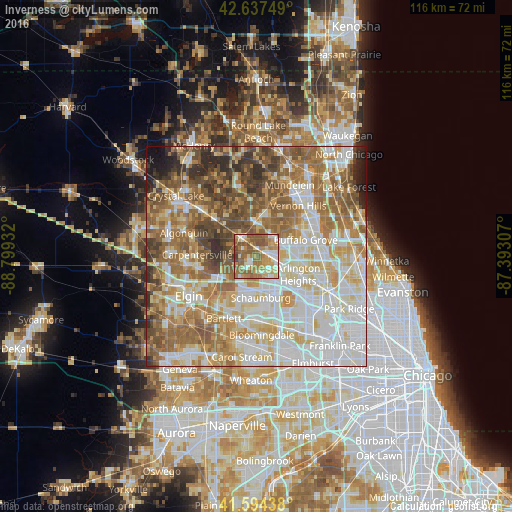
Analysis of Inverness night lights 2016
Square area 10x10 km:
 10.76%
90-99
13.33%80-89
10.45%70-79
14.85%60-69
21.52%50-59
24.24%40-49
3.79%30-39
1.06%20-29
0%10-19
0%0-9
0%Square area 50x50 km:
18.48%90-99
17%80-89
11.31%70-79
9.35%60-69
13.42%50-59
12.31%40-49
7.96%30-39
4.43%20-29
3.86%10-19
1.79%0-9
0.1%Clear (daylight) street map image can be seen on geolist.org.
Map coordinates:
42° 38' 15" North, 88° 47' 57.6" West
42° 7' 5.1" North, 88° 5' 46.3" West
41° 35' 39.8" North, 87° 23' 35.1" West
Some cities around Inverness sort by population:
• Arlington Heights
10.1 km =6.3 mi,  109°
109°
• Schaumburg
9.5 km =5.9 mi,  173°
173°
• Palatine
5.2 km =3.2 mi,  99°
99°
• Hoffman Estates
8.5 km =5.3 mi, 170°
• Rolling Meadows
7.8 km =4.8 mi,  118°
118°
• Lake Zurich
8.8 km =5.5 mi,  1°
1°
• Barrington
5.2 km =3.2 mi,  320°
320°
• Long Grove
10.5 km =6.5 mi,  50°
50°
4897482 (p: 7,583)
Sources (retrieved 2019-11-25):
» Earth at Night: Flat Maps 2012, 2016