Barrington night lights from space
Night Light of Barrington (Illinois) from space (United States) Src. Average luminocity for 10x10km area is 58.2879% and for 50x50km: 69.0644%.
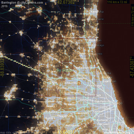
Analysis of Barrington night lights 2016
Square area 10x10 km:
 3.79%
3.79%90-99
5.45%80-89
4.85%70-79
6.67%60-69
13.94%50-59
30%40-49
26.36%30-39
8.33%20-29
0.61%10-19
0%0-9
0%Square area 50x50 km:
14.36%90-99
15.23%80-89
10.84%70-79
9.44%60-69
13.82%50-59
13.39%40-49
8.95%30-39
5.37%20-29
4.8%10-19
3.09%0-9
0.72%Clear (daylight) street map image can be seen on geolist.org.
Map coordinates:
42° 40' 22.9" North, 88° 50' 21.6" West
42° 9' 14.1" North, 88° 8' 10.3" West
41° 37' 49.8" North, 87° 25' 59.1" West
Some cities around Barrington sort by population:
• Palatine
9.7 km =6 mi,  119°
119°
• Carpentersville
10.7 km =6.6 mi,  250°
250°
• Lake Zurich
5.9 km =3.7 mi,  36°
36°
• Cary
10.6 km =6.6 mi,  307°
307°
• Long Grove
11.7 km =7.3 mi,  76°
76°
• Hawthorn Woods
10 km =6.2 mi,  45°
45°
• Inverness
5.2 km =3.2 mi,  140°
140°
• Fairfield
9.5 km =5.9 mi, 40°
4884116 (p: 10,353)
Sources (retrieved 2019-11-25):
» Earth at Night: Flat Maps 2012, 2016