Dyersburg night lights from space
Night Light of Dyersburg (Tennessee) from space (United States) Src. Average luminocity for 10x10km area is 55.5348% and for 50x50km: 5.6123%.
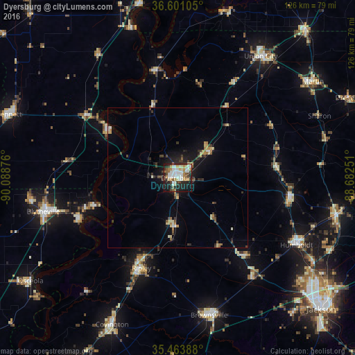
Analysis of Dyersburg night lights 2016
Square area 10x10 km:
 13.74%
90-99
15.02%80-89
4.95%70-79
8.06%60-69
5.13%50-59
5.49%40-49
2.56%30-39
9.52%20-29
14.47%10-19
19.6%0-9
1.47%Square area 50x50 km:
0.61%90-99
0.88%80-89
0.71%70-79
0.67%60-69
0.62%50-59
0.47%40-49
0.63%30-39
1.21%20-29
1.36%10-19
3.94%0-9
88.9%Clear (daylight) street map image can be seen on geolist.org.
Map coordinates:
36° 36' 3.8" North, 90° 5' 19.5" West
36° 2' 4.3" North, 89° 23' 8.3" West
35° 27' 50" North, 88° 40' 57" West
Some cities around Dyersburg sort by population:
• Blytheville
49.4 km =30.7 mi,  256°
256°
• Union City
52.4 km =32.6 mi,  34°
34°
• Brownsville
50.2 km =31.2 mi,  167°
167°
• Covington
57.3 km =35.6 mi,  204°
204°
• Humboldt
48.6 km =30.2 mi,  119°
119°
• Ripley
34.7 km =21.6 mi, 201°
• Milan
57.8 km =35.9 mi,  102°
102°
• Caruthersville
30 km =18.6 mi,  306°
306°
4619800 (p: 16,781)
Sources (retrieved 2019-11-25):
» Earth at Night: Flat Maps 2012, 2016