Brownsville night lights from space
Night Light of Brownsville (Tennessee) from space (United States) Src. Average luminocity for 10x10km area is 34.0699% and for 50x50km: 4.6188%.
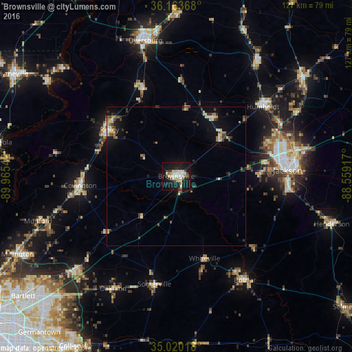
Analysis of Brownsville night lights 2016
Square area 10x10 km:
 5.59%
5.59%90-99
8.39%80-89
7.17%70-79
1.75%60-69
0.87%50-59
2.8%40-49
2.45%30-39
4.72%20-29
5.24%10-19
42.83%0-9
18.18%Square area 50x50 km:
0.36%90-99
0.65%80-89
0.84%70-79
0.42%60-69
0.46%50-59
0.48%40-49
0.62%30-39
0.92%20-29
0.84%10-19
3.91%0-9
90.49%Clear (daylight) street map image can be seen on geolist.org.
Map coordinates:
36° 9' 49.2" North, 89° 57' 55.5" West
35° 35' 38.3" North, 89° 15' 44.2" West
35° 1' 12.6" North, 88° 33' 33" West
Some cities around Brownsville sort by population:
• Jackson
40.6 km =25.2 mi,  86°
86°
• Arlington
49 km =30.4 mi,  227°
227°
• Atoka
49.7 km =30.9 mi,  250°
250°
• Covington
34.9 km =21.7 mi,  264°
264°
• Humboldt
40.1 km =24.9 mi,  51°
51°
• Ripley
29.4 km =18.3 mi,  304°
304°
• Oakland
46.6 km =29 mi,  209°
209°
• Bolivar
45 km =28 mi,  146°
146°
4609116 (p: 9,876)
Sources (retrieved 2019-11-25):
» Earth at Night: Flat Maps 2012, 2016