Camp Swift night lights from space
Night Light of Camp Swift (Texas) from space (United States) Src. Average luminocity for 10x10km area is 15.1696% and for 50x50km: 6.3203%.
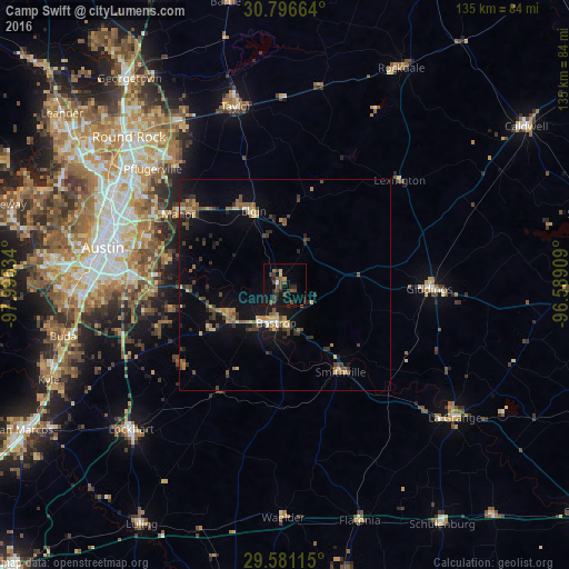
Analysis of Camp Swift night lights 2016
Square area 10x10 km:
 0.17%
0.17%90-99
0.52%80-89
1.4%70-79
0.7%60-69
1.22%50-59
3.32%40-49
5.42%30-39
5.94%20-29
5.24%10-19
14.51%0-9
61.54%Square area 50x50 km:
0.19%90-99
0.29%80-89
0.84%70-79
0.62%60-69
1.08%50-59
1.25%40-49
1.36%30-39
1.43%20-29
1.35%10-19
4.87%0-9
86.71%Clear (daylight) street map image can be seen on geolist.org.
Map coordinates:
30° 47' 47.9" North, 97° 59' 43.2" West
30° 11' 26.8" North, 97° 17' 32" West
29° 34' 52.1" North, 96° 35' 20.7" West
Some cities around Camp Swift sort by population:
• Austin
44.1 km =27.4 mi,  281°
281°
• Pflugerville
41.9 km =26 mi,  311°
311°
• Taylor
43.7 km =27.2 mi,  345°
345°
• Elgin
19.2 km =11.9 mi,  337°
337°
• Bastrop
9.2 km =5.7 mi,  193°
193°
• Manor
30.4 km =18.9 mi,  303°
303°
• Hornsby Bend
28.7 km =17.8 mi, 282°
• Giddings
34.2 km =21.3 mi,  91°
91°
4678565 (p: 6,383)
Sources (retrieved 2019-11-25):
» Earth at Night: Flat Maps 2012, 2016