Elgin night lights from space
Night Light of Elgin (Texas) from space (United States) Src. Average luminocity for 10x10km area is 16.8828% and for 50x50km: 12.5577%.
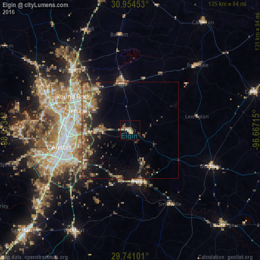
Analysis of Elgin night lights 2016
Square area 10x10 km:
 0.92%
0.92%90-99
1.28%80-89
2.93%70-79
1.83%60-69
4.03%50-59
4.76%40-49
1.83%30-39
1.28%20-29
1.1%10-19
3.85%0-9
76.19%Square area 50x50 km:
0.58%90-99
0.85%80-89
1.68%70-79
2.01%60-69
2.55%50-59
3.22%40-49
2.53%30-39
2.66%20-29
3.43%10-19
6.76%0-9
73.74%Clear (daylight) street map image can be seen on geolist.org.
Map coordinates:
30° 57' 16.3" North, 98° 4' 24.2" West
30° 20' 58.7" North, 97° 22' 13" West
29° 44' 27.6" North, 96° 40' 1.7" West
Some cities around Elgin sort by population:
• Pflugerville
25.9 km =16.1 mi,  292°
292°
• Hutto
27.3 km =17 mi,  321°
321°
• Taylor
24.9 km =15.5 mi,  351°
351°
• Wells Branch
31.5 km =19.6 mi, 289°
• Bastrop
27.1 km =16.8 mi,  168°
168°
• Manor
17.9 km =11.1 mi,  266°
266°
• Hornsby Bend
23.4 km =14.5 mi,  240°
240°
• Camp Swift
19.2 km =11.9 mi,  157°
157°
4688756 (p: 9,039)
Sources (retrieved 2019-11-25):
» Earth at Night: Flat Maps 2012, 2016