Homeland night lights from space
Night Light of Homeland (California) from space (United States) Src. Average luminocity for 10x10km area is 29.6593% and for 50x50km: 33.2664%.
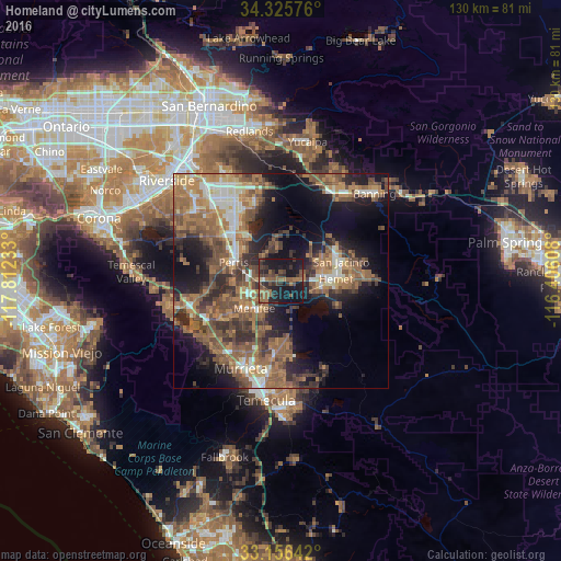
Analysis of Homeland night lights 2016
Square area 10x10 km:
 0.37%
0.37%90-99
0.37%80-89
0.73%70-79
0%60-69
9.71%50-59
9.16%40-49
10.44%30-39
10.44%20-29
9.71%10-19
45.42%0-9
3.66%Square area 50x50 km:
3.02%90-99
3.8%80-89
2.34%70-79
4.35%60-69
9.89%50-59
8.56%40-49
8.2%30-39
5.53%20-29
7.42%10-19
15.08%0-9
31.8%Clear (daylight) street map image can be seen on geolist.org.
Map coordinates:
34° 19' 32.7" North, 117° 48' 44.4" West
33° 44' 35.1" North, 117° 6' 33.1" West
33° 9' 23.1" North, 116° 24' 21.9" West
Some cities around Homeland sort by population:
• Menifee
3.8 km =2.4 mi,  244°
244°
• Hemet
12.6 km =7.8 mi,  87°
87°
• Perris
11.9 km =7.4 mi,  291°
291°
• San Jacinto
14.6 km =9.1 mi,  71°
71°
• Sun City
9 km =5.6 mi,  245°
245°
• East Hemet
15.7 km =9.8 mi, 91°
• Good Hope
14.8 km =9.2 mi,  279°
279°
• Nuevo
7.3 km =4.5 mi,  332°
332°
5357755 (p: 5,969)
Sources (retrieved 2019-11-25):
» Earth at Night: Flat Maps 2012, 2016