Good Hope night lights from space
Night Light of Good Hope (California) from space (United States) Src. Average luminocity for 10x10km area is 41.9615% and for 50x50km: 38.0027%.
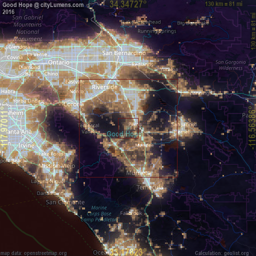
Analysis of Good Hope night lights 2016
Square area 10x10 km:
 3.85%
3.85%90-99
3.48%80-89
0.18%70-79
4.03%60-69
9.89%50-59
7.33%40-49
23.63%30-39
9.71%20-29
20.33%10-19
17.4%0-9
0.18%Square area 50x50 km:
4.07%90-99
4.94%80-89
2.63%70-79
5.22%60-69
12.34%50-59
8.87%40-49
7.94%30-39
5.82%20-29
7.91%10-19
14.76%0-9
25.5%Clear (daylight) street map image can be seen on geolist.org.
Map coordinates:
34° 20' 50.2" North, 117° 58' 12.4" West
33° 45' 53.1" North, 117° 16' 1.1" West
33° 10' 41.6" North, 116° 33' 49.9" West
Some cities around Good Hope sort by population:
• Menifee
11.9 km =7.4 mi,  109°
109°
• Perris
4.1 km =2.5 mi,  60°
60°
• Lake Elsinore
12.1 km =7.5 mi,  207°
207°
• Sun City
8.9 km =5.5 mi,  133°
133°
• Mead Valley
8.1 km =5 mi,  340°
340°
• Canyon Lake
8.9 km =5.5 mi,  183°
183°
• Nuevo
11.9 km =7.4 mi,  69°
69°
• Homeland
14.8 km =9.2 mi,  99°
99°
5353058 (p: 9,192)
Sources (retrieved 2019-11-25):
» Earth at Night: Flat Maps 2012, 2016