East Hemet night lights from space
Night Light of East Hemet (California) from space (United States) Src. Average luminocity for 10x10km area is 49.5952% and for 50x50km: 19.1502%.
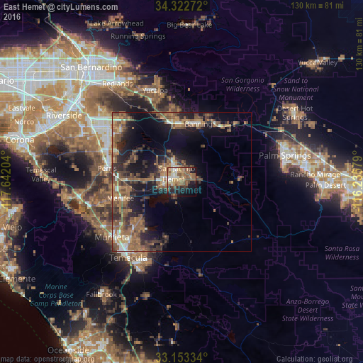
Analysis of East Hemet night lights 2016
Square area 10x10 km:
 4.4%
4.4%90-99
6.04%80-89
7.14%70-79
8.61%60-69
13.55%50-59
15.38%40-49
7.33%30-39
2.75%20-29
8.97%10-19
20.51%0-9
5.31%Square area 50x50 km:
1.27%90-99
1.7%80-89
1.12%70-79
2.24%60-69
5.7%50-59
5.34%40-49
4.74%30-39
3.8%20-29
4.74%10-19
11.51%0-9
57.86%Clear (daylight) street map image can be seen on geolist.org.
Map coordinates:
34° 19' 21.8" North, 117° 38' 31.3" West
33° 44' 24.1" North, 116° 56' 20.1" West
33° 9' 12" North, 116° 14' 8.8" West
Some cities around East Hemet sort by population:
• Menifee
19.2 km =11.9 mi,  266°
266°
• Hemet
3.3 km =2.1 mi,  284°
284°
• San Jacinto
5.2 km =3.2 mi,  339°
339°
• Beaumont
21.4 km =13.3 mi,  350°
350°
• Banning
21.4 km =13.3 mi,  15°
15°
• Valle Vista
4.3 km =2.7 mi,  78°
78°
• Nuevo
20.3 km =12.6 mi,  289°
289°
• Homeland
15.7 km =9.8 mi, 271°
5344942 (p: 17,418)
Sources (retrieved 2019-11-25):
» Earth at Night: Flat Maps 2012, 2016