Holly Springs night lights from space
Night Light of Holly Springs (Mississippi) from space (United States) Src. Average luminocity for 10x10km area is 37.7784% and for 50x50km: 7.8257%.
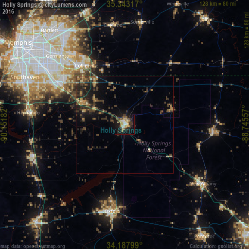
Analysis of Holly Springs night lights 2016
Square area 10x10 km:
 3.48%
3.48%90-99
6.04%80-89
7.14%70-79
6.41%60-69
5.49%50-59
2.75%40-49
4.58%30-39
9.16%20-29
8.24%10-19
34.98%0-9
11.72%Square area 50x50 km:
0.18%90-99
0.5%80-89
0.85%70-79
1.13%60-69
1.19%50-59
1.2%40-49
1.9%30-39
2.95%20-29
2.7%10-19
6.34%0-9
81.06%Clear (daylight) street map image can be seen on geolist.org.
Map coordinates:
35° 20' 35.4" North, 90° 9' 6.6" West
34° 46' 3.4" North, 89° 26' 55.3" West
34° 11' 16.8" North, 88° 44' 44.1" West
Some cities around Holly Springs sort by population:
• Collierville
36.3 km =22.6 mi,  327°
327°
• Germantown
48.4 km =30.1 mi,  317°
317°
• Olive Branch
40.9 km =25.4 mi,  301°
301°
• Oxford
45.1 km =28 mi,  188°
188°
• Hernando
50.2 km =31.2 mi,  277°
277°
• New Albany
50.5 km =31.4 mi,  126°
126°
• Senatobia
50.4 km =31.3 mi,  250°
250°
• Ripley
45.7 km =28.4 mi,  95°
95°
4430104 (p: 7,610)
Sources (retrieved 2019-11-25):
» Earth at Night: Flat Maps 2012, 2016