Senatobia night lights from space
Night Light of Senatobia (Mississippi) from space (United States) Src. Average luminocity for 10x10km area is 33.0874% and for 50x50km: 5.9521%.
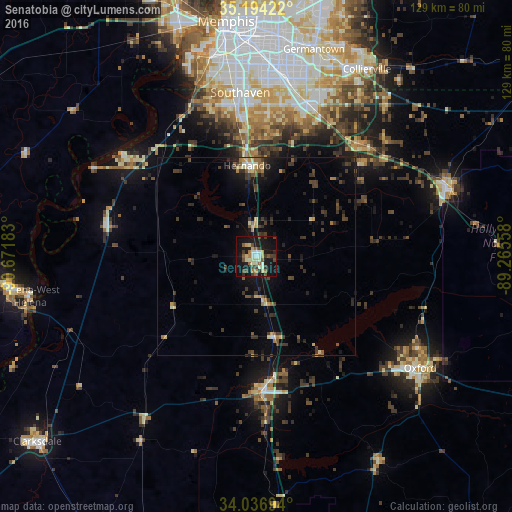
Analysis of Senatobia night lights 2016
Square area 10x10 km:
 2.97%
2.97%90-99
5.94%80-89
6.47%70-79
1.4%60-69
3.32%50-59
5.59%40-49
7.17%30-39
4.9%20-29
3.32%10-19
42.48%0-9
16.43%Square area 50x50 km:
0.25%90-99
0.47%80-89
0.89%70-79
0.4%60-69
0.58%50-59
0.88%40-49
1.2%30-39
2.11%20-29
1.43%10-19
5.2%0-9
86.6%Clear (daylight) street map image can be seen on geolist.org.
Map coordinates:
35° 11' 39.2" North, 90° 40' 18.6" West
34° 37' 3.4" North, 89° 58' 7.3" West
34° 2' 13" North, 89° 15' 56.1" West
Some cities around Senatobia sort by population:
• New South Memphis
52.8 km =32.8 mi,  351°
351°
• Southaven
41.5 km =25.8 mi, 354°
• Olive Branch
40.3 km =25 mi,  18°
18°
• Horn Lake
38 km =23.6 mi, 350°
• Oxford
49.8 km =30.9 mi,  124°
124°
• Hernando
23.1 km =14.4 mi, 354°
• Holly Springs
50.4 km =31.3 mi,  70°
70°
• Batesville
34.1 km =21.2 mi,  176°
176°
4445447 (p: 7,963)
Sources (retrieved 2019-11-25):
» Earth at Night: Flat Maps 2012, 2016