Healdsburg night lights from space
Night Light of Healdsburg (California) from space (United States) Src. Average luminocity for 10x10km area is 9.8393% and for 50x50km: 7.0464%.
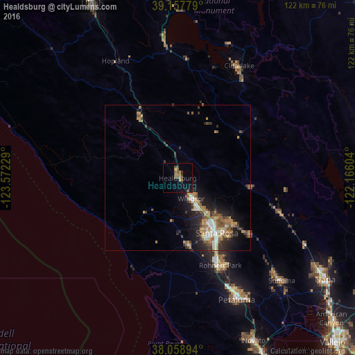
Analysis of Healdsburg night lights 2016
Square area 10x10 km:
 0%
0%90-99
0%80-89
0.16%70-79
2.92%60-69
1.46%50-59
2.27%40-49
3.41%30-39
1.79%20-29
0.49%10-19
5.36%0-9
82.14%Square area 50x50 km:
0.72%90-99
0.91%80-89
0.4%70-79
1.68%60-69
1.23%50-59
1.23%40-49
0.96%30-39
1.34%20-29
1.87%10-19
4.19%0-9
85.47%Clear (daylight) street map image can be seen on geolist.org.
Map coordinates:
39° 9' 28" North, 123° 34' 20.2" West
38° 36' 37.7" North, 122° 52' 9" West
38° 3' 32.2" North, 122° 9' 57.7" West
Some cities around Healdsburg sort by population:
• Santa Rosa
23.2 km =14.4 mi,  144°
144°
• Rohnert Park
33.5 km =20.8 mi,  154°
154°
• Windsor
8.4 km =5.2 mi, 146°
• Larkfield-Wikiup
14.9 km =9.3 mi, 136°
• Cloverdale
25.2 km =15.7 mi,  329°
329°
• Sebastopol
23.5 km =14.6 mi,  170°
170°
• Roseland
24.3 km =15.1 mi, 149°
• Calistoga
25.4 km =15.8 mi,  97°
97°
5356012 (p: 11,742)
Sources (retrieved 2019-11-25):
» Earth at Night: Flat Maps 2012, 2016