Sebastopol night lights from space
Night Light of Sebastopol (California) from space (United States) Src. Average luminocity for 10x10km area is 14.4968% and for 50x50km: 9.7057%.
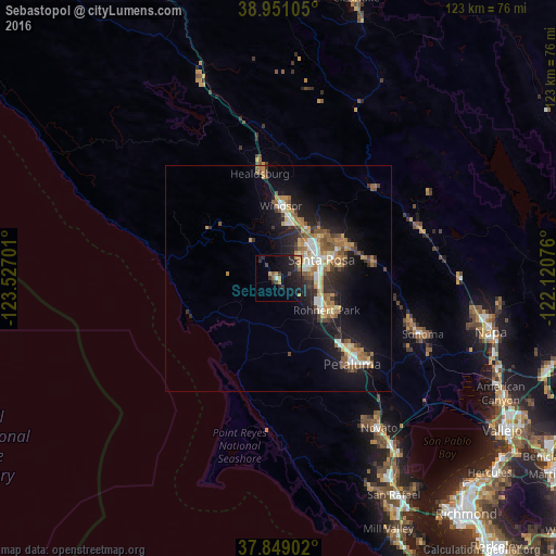
Analysis of Sebastopol night lights 2016
Square area 10x10 km:
 0.49%
0.49%90-99
0.16%80-89
0.32%70-79
4.38%60-69
1.3%50-59
1.79%40-49
2.6%30-39
3.9%20-29
7.14%10-19
19.48%0-9
58.44%Square area 50x50 km:
1.07%90-99
1.36%80-89
0.66%70-79
1.8%60-69
1.64%50-59
1.6%40-49
1.23%30-39
1.58%20-29
2.42%10-19
8.04%0-9
78.62%Clear (daylight) street map image can be seen on geolist.org.
Map coordinates:
38° 57' 3.8" North, 123° 31' 37.2" West
38° 24' 7.7" North, 122° 49' 26" West
37° 50' 56.5" North, 122° 7' 14.7" West
Some cities around Sebastopol sort by population:
• Santa Rosa
10.4 km =6.5 mi,  65°
65°
• Petaluma
25 km =15.5 mi,  139°
139°
• Rohnert Park
12.8 km =8 mi,  122°
122°
• Windsor
16.1 km =10 mi,  2°
2°
• Healdsburg
23.5 km =14.6 mi,  350°
350°
• Larkfield-Wikiup
13.9 km =8.6 mi,  27°
27°
• Cotati
13.2 km =8.2 mi,  129°
129°
• Roseland
8.6 km =5.3 mi,  75°
75°
5394165 (p: 7,678)
Sources (retrieved 2019-11-25):
» Earth at Night: Flat Maps 2012, 2016