Calistoga night lights from space
Night Light of Calistoga (California) from space (United States) Src. Average luminocity for 10x10km area is 1.9464% and for 50x50km: 7.8166%.
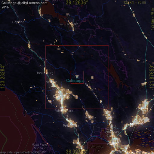
Analysis of Calistoga night lights 2016
Square area 10x10 km:
 0%
0%90-99
0%80-89
0%70-79
0%60-69
0.49%50-59
1.46%40-49
0.65%30-39
1.3%20-29
0%10-19
0%0-9
96.1%Square area 50x50 km:
0.8%90-99
0.99%80-89
0.47%70-79
1.61%60-69
1.46%50-59
1.2%40-49
1.08%30-39
1.51%20-29
2.36%10-19
5.05%0-9
83.47%Clear (daylight) street map image can be seen on geolist.org.
Map coordinates:
39° 7' 34.9" North, 123° 16' 58.2" West
38° 34' 43.7" North, 122° 34' 47" West
38° 1' 37.3" North, 121° 52' 35.7" West
Some cities around Calistoga sort by population:
• Santa Rosa
19.3 km =12 mi,  217°
217°
• Rohnert Park
28.6 km =17.8 mi,  201°
201°
• Windsor
20.9 km =13 mi,  260°
260°
• Healdsburg
25.4 km =15.8 mi,  277°
277°
• Larkfield-Wikiup
16.6 km =10.3 mi,  243°
243°
• Roseland
21.7 km =13.5 mi, 216°
• Saint Helena
12.6 km =7.8 mi,  130°
130°
• Hidden Valley Lake
25.5 km =15.8 mi,  4°
4°
5332937 (p: 5,330)
Sources (retrieved 2019-11-25):
» Earth at Night: Flat Maps 2012, 2016