Superior night lights from space
Night Light of Superior (Colorado) from space (United States) Src. Average luminocity for 10x10km area is 50.4048% and for 50x50km: 38.6172%.
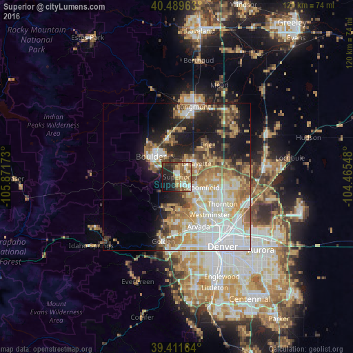
Analysis of Superior night lights 2016
Square area 10x10 km:
 6.12%
6.12%90-99
7.48%80-89
6.97%70-79
8.67%60-69
13.78%50-59
10.37%40-49
4.76%30-39
3.57%20-29
18.71%10-19
14.97%0-9
4.59%Square area 50x50 km:
9.91%90-99
7.25%80-89
5.66%70-79
6.4%60-69
5.09%50-59
4.89%40-49
3.5%30-39
3.26%20-29
5.88%10-19
11.82%0-9
36.33%Clear (daylight) street map image can be seen on geolist.org.
Map coordinates:
40° 29' 22.7" North, 105° 52' 18.2" West
39° 57' 9.9" North, 105° 10' 7" West
39° 24' 41.9" North, 104° 27' 55.7" West
Some cities around Superior sort by population:
• Westminster
17.1 km =10.6 mi,  139°
139°
• Boulder
11.1 km =6.9 mi,  308°
308°
• Broomfield
7.9 km =4.9 mi,  117°
117°
• Lafayette
8.1 km =5 mi,  55°
55°
• Erie
14.8 km =9.2 mi,  42°
42°
• Louisville
4.2 km =2.6 mi,  48°
48°
• Gunbarrel
12.3 km =7.6 mi,  359°
359°
• Shaw Heights
15.5 km =9.6 mi, 136°
5440838 (p: 12,980)
Sources (retrieved 2019-11-25):
» Earth at Night: Flat Maps 2012, 2016