Arroyo Grande night lights from space
Night Light of Arroyo Grande (California) from space (United States) Src. Average luminocity for 10x10km area is 29.0927% and for 50x50km: 7.4976%.
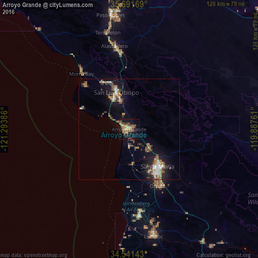
Analysis of Arroyo Grande night lights 2016
Square area 10x10 km:
 1.22%
1.22%90-99
2.27%80-89
2.8%70-79
4.55%60-69
8.22%50-59
5.24%40-49
6.82%30-39
6.29%20-29
2.45%10-19
33.74%0-9
26.4%Square area 50x50 km:
0.72%90-99
0.98%80-89
0.38%70-79
1.16%60-69
1.28%50-59
1.05%40-49
1.6%30-39
1.14%20-29
1.57%10-19
6.45%0-9
83.68%Clear (daylight) street map image can be seen on geolist.org.
Map coordinates:
35° 41' 30.1" North, 121° 17' 37.9" West
35° 7' 6.9" North, 120° 35' 26.6" West
34° 32' 29.1" North, 119° 53' 15.4" West
Some cities around Arroyo Grande sort by population:
• Santa Maria
23.2 km =14.4 mi,  142°
142°
• San Luis Obispo
19.3 km =12 mi,  341°
341°
• Nipomo
13.4 km =8.3 mi,  128°
128°
• Los Osos
30.7 km =19.1 mi,  314°
314°
• Grover Beach
2.8 km =1.7 mi,  276°
276°
• Pismo Beach
5.3 km =3.3 mi,  300°
300°
• Guadalupe
16.4 km =10.2 mi,  173°
173°
• Oceano
2.9 km =1.8 mi,  221°
221°
5324802 (p: 18,108)
Sources (retrieved 2019-11-25):
» Earth at Night: Flat Maps 2012, 2016