Spring Ridge night lights from space
Night Light of Spring Ridge (Maryland) from space (United States) Src. Average luminocity for 10x10km area is 49.0918% and for 50x50km: 16.4393%.
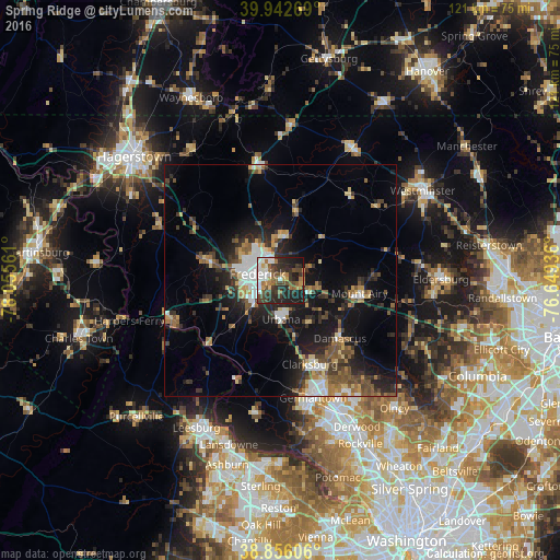
Analysis of Spring Ridge night lights 2016
Square area 10x10 km:
 9.69%
9.69%90-99
8.67%80-89
1.87%70-79
5.95%60-69
6.29%50-59
9.52%40-49
9.35%30-39
12.76%20-29
19.56%10-19
16.16%0-9
0.17%Square area 50x50 km:
2.27%90-99
1.95%80-89
1.69%70-79
1.73%60-69
2.12%50-59
2.81%40-49
2.77%30-39
3.52%20-29
5.1%10-19
11.75%0-9
64.28%Clear (daylight) street map image can be seen on geolist.org.
Map coordinates:
39° 56' 33.7" North, 78° 3' 20.2" West
39° 24' 5.4" North, 77° 21' 8.9" West
38° 51' 21.8" North, 76° 38' 57.7" West
Some cities around Spring Ridge sort by population:
• Frederick
5.2 km =3.2 mi,  285°
285°
• Ballenger Creek
7.8 km =4.8 mi,  245°
245°
• Damascus
17.9 km =11.1 mi,  134°
134°
• Green Valley
11.3 km =7 mi,  155°
155°
• Mount Airy
17.2 km =10.7 mi,  99°
99°
• Urbana
8.4 km =5.2 mi,  179°
179°
• Linganore
13.1 km =8.1 mi,  70°
70°
• Walkersville
9.4 km =5.8 mi,  0°
0°
4370201 (p: 5,795)
Sources (retrieved 2019-11-25):
» Earth at Night: Flat Maps 2012, 2016