Canyon Lake night lights from space
Night Light of Canyon Lake (California) from space (United States) Src. Average luminocity for 10x10km area is 49.7234% and for 50x50km: 30.6228%.
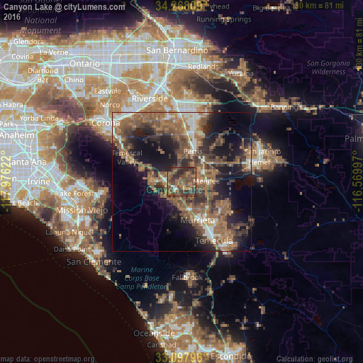
Analysis of Canyon Lake night lights 2016
Square area 10x10 km:
 1.47%
1.47%90-99
1.65%80-89
0.73%70-79
6.23%60-69
18.86%50-59
13.55%40-49
29.49%30-39
16.3%20-29
11.54%10-19
0.18%0-9
0%Square area 50x50 km:
2.48%90-99
3.08%80-89
1.45%70-79
3.18%60-69
9.85%50-59
8.95%40-49
7.97%30-39
6.06%20-29
7.93%10-19
14.3%0-9
34.75%Clear (daylight) street map image can be seen on geolist.org.
Map coordinates:
34° 16' 5.1" North, 117° 58' 34.4" West
33° 41' 6.1" North, 117° 16' 23.1" West
33° 5' 52.7" North, 116° 34' 11.9" West
Some cities around Canyon Lake sort by population:
• Murrieta
15.6 km =9.7 mi,  159°
159°
• Menifee
12.7 km =7.9 mi,  67°
67°
• Perris
11.6 km =7.2 mi,  20°
20°
• Lake Elsinore
5.4 km =3.4 mi,  249°
249°
• Wildomar
9.6 km =6 mi,  183°
183°
• Sun City
7.5 km =4.7 mi, 69°
• Lakeland Village
8.3 km =5.2 mi,  231°
231°
• Good Hope
8.9 km =5.5 mi,  3°
3°
5333976 (p: 11,080)
Sources (retrieved 2019-11-25):
» Earth at Night: Flat Maps 2012, 2016