Golden Hills night lights from space
Night Light of Golden Hills (California) from space (United States) Src. Average luminocity for 10x10km area is 17.1154% and for 50x50km: 1.3919%.
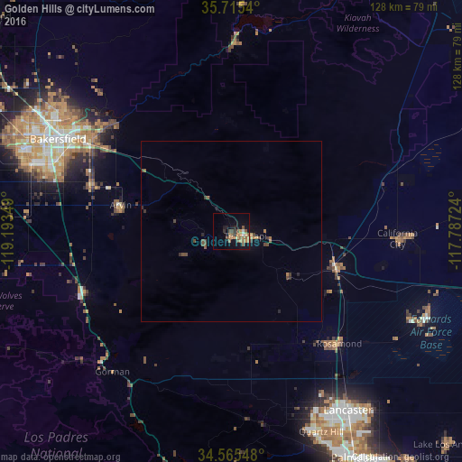
Analysis of Golden Hills night lights 2016
Square area 10x10 km:
 0.35%
0.35%90-99
1.05%80-89
1.4%70-79
3.32%60-69
5.77%50-59
4.2%40-49
3.85%30-39
1.22%20-29
2.1%10-19
10.84%0-9
65.91%Square area 50x50 km:
0.01%90-99
0.04%80-89
0.06%70-79
0.25%60-69
0.36%50-59
0.32%40-49
0.48%30-39
0.24%20-29
0.2%10-19
0.6%0-9
97.42%Clear (daylight) street map image can be seen on geolist.org.
Map coordinates:
35° 42' 55.4" North, 119° 11' 36.6" West
35° 8' 32.9" North, 118° 29' 25.3" West
34° 33' 55.7" North, 117° 47' 14.1" West
Some cities around Golden Hills sort by population:
• Bakersfield
54.4 km =33.8 mi,  298°
298°
• Oildale
57.1 km =35.5 mi, 302°
• Arvin
31.6 km =19.6 mi,  283°
283°
• Rosamond
42.9 km =26.7 mi,  136°
136°
• Lamont
40.7 km =25.3 mi,  288°
288°
• California City
45.9 km =28.5 mi,  92°
92°
• Tehachapi
3.9 km =2.4 mi,  106°
106°
• Bear Valley Springs
12.7 km =7.9 mi, 278°
5352875 (p: 8,656)
Sources (retrieved 2019-11-25):
» Earth at Night: Flat Maps 2012, 2016