Garrett night lights from space
Night Light of Garrett (Indiana) from space (United States) Src. Average luminocity for 10x10km area is 21.5544% and for 50x50km: 11.6606%.
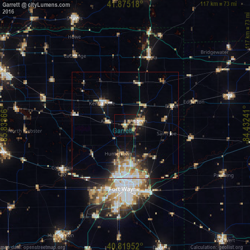
Analysis of Garrett night lights 2016
Square area 10x10 km:
 1.02%
1.02%90-99
1.36%80-89
3.06%70-79
5.1%60-69
2.72%50-59
4.76%40-49
2.21%30-39
1.02%20-29
5.78%10-19
24.83%0-9
48.13%Square area 50x50 km:
1.37%90-99
1.86%80-89
1.87%70-79
1.5%60-69
1.52%50-59
1.54%40-49
1.66%30-39
1.26%20-29
2.36%10-19
6.6%0-9
78.46%Clear (daylight) street map image can be seen on geolist.org.
Map coordinates:
41° 52' 30.6" North, 85° 50' 19.2" West
41° 20' 58.2" North, 85° 8' 7.9" West
40° 49' 10.3" North, 84° 25' 56.7" West
Some cities around Garrett sort by population:
• Fort Wayne
24.3 km =15.1 mi,  178°
178°
• New Haven
32.6 km =20.3 mi,  161°
161°
• Auburn
6.7 km =4.2 mi,  73°
73°
• Kendallville
14.9 km =9.3 mi,  313°
313°
• Columbia City
36.4 km =22.6 mi,  234°
234°
• Angola
33.7 km =20.9 mi,  19°
19°
• Bryan
50.6 km =31.4 mi, 74°
• Huntertown
13.8 km =8.6 mi,  192°
192°
4920600 (p: 6,344)
Sources (retrieved 2019-11-25):
» Earth at Night: Flat Maps 2012, 2016