Auburn night lights from space
Night Light of Auburn (Indiana) from space (United States) Src. Average luminocity for 10x10km area is 33.9813% and for 50x50km: 9.9396%.
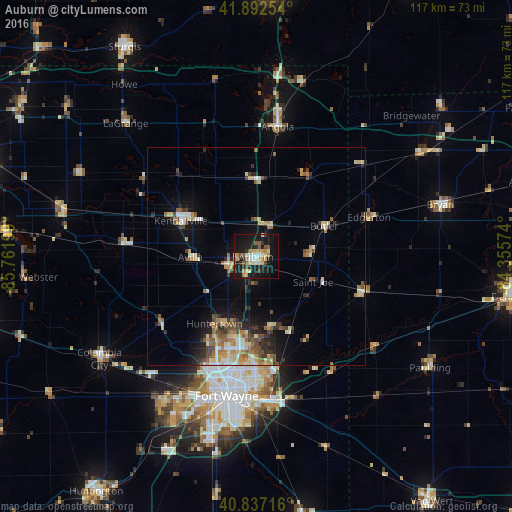
Analysis of Auburn night lights 2016
Square area 10x10 km:
 3.91%
3.91%90-99
4.42%80-89
7.14%70-79
4.42%60-69
3.23%50-59
5.95%40-49
2.89%30-39
2.38%20-29
7.82%10-19
43.54%0-9
14.29%Square area 50x50 km:
0.82%90-99
1.3%80-89
1.64%70-79
1.34%60-69
1.43%50-59
1.49%40-49
1.58%30-39
1.21%20-29
2.12%10-19
6.22%0-9
80.83%Clear (daylight) street map image can be seen on geolist.org.
Map coordinates:
41° 53' 33.1" North, 85° 45' 43.2" West
41° 22' 1.2" North, 85° 3' 31.9" West
40° 50' 13.8" North, 84° 21' 20.7" West
Some cities around Auburn sort by population:
• Fort Wayne
26.9 km =16.7 mi,  192°
192°
• New Haven
33.2 km =20.6 mi,  173°
173°
• Kendallville
19.1 km =11.9 mi,  295°
295°
• Columbia City
42.8 km =26.6 mi,  236°
236°
• Angola
30.2 km =18.8 mi,  9°
9°
• Bryan
43.9 km =27.3 mi,  74°
74°
• Garrett
6.7 km =4.2 mi,  253°
253°
• Huntertown
18.1 km =11.2 mi,  211°
211°
4917712 (p: 12,979)
Sources (retrieved 2019-11-25):
» Earth at Night: Flat Maps 2012, 2016