Bryan night lights from space
Night Light of Bryan (Ohio) from space (United States) Src. Average luminocity for 10x10km area is 16.1497% and for 50x50km: 5.0136%.
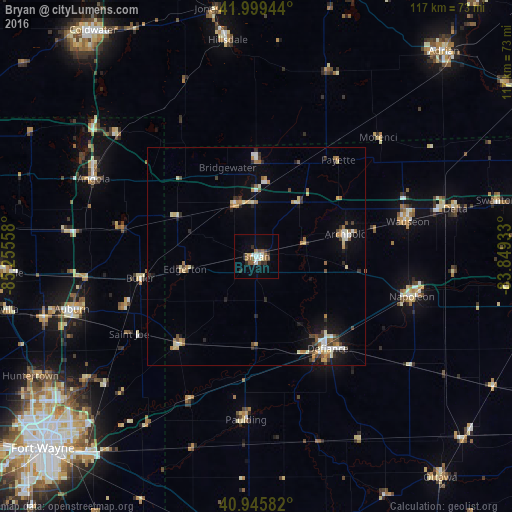
Analysis of Bryan night lights 2016
Square area 10x10 km:
 2.72%
2.72%90-99
2.04%80-89
0.68%70-79
0.85%60-69
3.4%50-59
3.23%40-49
2.21%30-39
2.38%20-29
2.21%10-19
3.23%0-9
77.04%Square area 50x50 km:
0.55%90-99
0.76%80-89
0.58%70-79
0.59%60-69
0.77%50-59
0.62%40-49
0.67%30-39
0.64%20-29
0.79%10-19
2.04%0-9
91.98%Clear (daylight) street map image can be seen on geolist.org.
Map coordinates:
41° 59' 58" North, 85° 15' 20.1" West
41° 28' 29.2" North, 84° 33' 8.8" West
40° 56' 45" North, 83° 50' 57.6" West
Some cities around Bryan sort by population:
• Defiance
26.8 km =16.7 mi,  142°
142°
• Auburn
43.9 km =27.3 mi,  254°
254°
• Angola
41.2 km =25.6 mi,  295°
295°
• Napoleon
36.8 km =22.9 mi,  104°
104°
• Hillsdale
49.9 km =31 mi,  352°
352°
• Wauseon
35.2 km =21.9 mi,  76°
76°
• Garrett
50.6 km =31.4 mi, 254°
• Huntertown
58.6 km =36.4 mi,  242°
242°
5148533 (p: 8,436)
Sources (retrieved 2019-11-25):
» Earth at Night: Flat Maps 2012, 2016