Columbia City night lights from space
Night Light of Columbia City (Indiana) from space (United States) Src. Average luminocity for 10x10km area is 15.8782% and for 50x50km: 8.4381%.
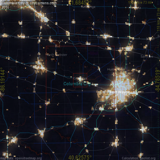
Analysis of Columbia City night lights 2016
Square area 10x10 km:
 1.62%
1.62%90-99
3.57%80-89
0.65%70-79
1.95%60-69
0.32%50-59
1.62%40-49
5.03%30-39
1.62%20-29
2.6%10-19
6.66%0-9
74.35%Square area 50x50 km:
0.73%90-99
1.2%80-89
1.08%70-79
1.01%60-69
1.31%50-59
1.29%40-49
1.31%30-39
1.63%20-29
2.74%10-19
4.33%0-9
83.38%Clear (daylight) street map image can be seen on geolist.org.
Map coordinates:
41° 41' 4.3" North, 86° 11' 29.2" West
41° 9' 26.2" North, 85° 29' 17.9" West
40° 37' 32.7" North, 84° 47' 6.7" West
Some cities around Columbia City sort by population:
• Fort Wayne
30.2 km =18.8 mi,  95°
95°
• Huntington
30.5 km =19 mi,  181°
181°
• New Haven
40.9 km =25.4 mi, 103°
• Warsaw
31.8 km =19.8 mi,  286°
286°
• Kendallville
36.7 km =22.8 mi,  30°
30°
• Garrett
36.4 km =22.6 mi,  54°
54°
• North Manchester
29.2 km =18.1 mi,  233°
233°
• Huntertown
27.6 km =17.1 mi,  73°
73°
4919203 (p: 8,857)
Sources (retrieved 2019-11-25):
» Earth at Night: Flat Maps 2012, 2016