Fruita night lights from space
Night Light of Fruita (Colorado) from space (United States) Src. Average luminocity for 10x10km area is 13.1899% and for 50x50km: 5.8818%.
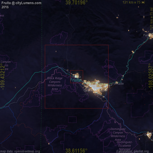
Analysis of Fruita night lights 2016
Square area 10x10 km:
 0.97%
0.97%90-99
0.97%80-89
0.81%70-79
2.11%60-69
2.76%50-59
1.95%40-49
2.11%30-39
3.9%20-29
0.32%10-19
3.9%0-9
80.19%Square area 50x50 km:
0.77%90-99
0.69%80-89
0.81%70-79
0.67%60-69
1.3%50-59
1.06%40-49
0.58%30-39
0.86%20-29
1.44%10-19
3.74%0-9
88.08%Clear (daylight) street map image can be seen on geolist.org.
Map coordinates:
39° 42' 7.1" North, 109° 25' 55.6" West
39° 9' 31.9" North, 108° 43' 44.4" West
38° 36' 41.6" North, 108° 1' 33.1" West
Some cities around Fruita sort by population:
• Grand Junction
18.7 km =11.6 mi,  124°
124°
• Clifton
25.3 km =15.7 mi,  107°
107°
• Montrose
105.8 km =65.7 mi,  135°
135°
• Rifle
91.4 km =56.8 mi,  62°
62°
• Delta
73.5 km =45.7 mi,  129°
129°
• Redlands
12 km =7.5 mi, 137°
• Orchard Mesa
20 km =12.4 mi, 130°
• Moab
96.4 km =59.9 mi,  227°
227°
5422534 (p: 12,795)
Sources (retrieved 2019-11-25):
» Earth at Night: Flat Maps 2012, 2016